W3/SV-060 White Mountain

White Mountain has only been activated twice before, by two prolific W3 activators NK8Q and W3QP. It’s probably because of how strenuous the climb is, though I found the activation itself to be more pleasant than the one I just finished, W3/PW-029 Thick Mtn. Driving to this last hike of the day required me to drive past Poe Valley State Park and Poe Paddy State Park in succession along the scenic Penns Creek, which is evidently prime for trout fishing. These looked like nice parks to overnight in, so I’ll definitely be back to the area.

I parked at Havice Valley Road about 1.2 miles down the road from Poe Paddy State Park, as reported by W3QP. Here off the side of the road there was room for 2-3 cars to park, across from the driveway for a cabin. A short walk down this driveway is a bouncy suspension bridge over Swift Run, which continues as Long Path trail along the edge of Peens Creek Wild Area, marked with yellow blazes.

Before long, the hike became a relentless uphill trudge. The first 3/4 of a mile was not too bad, with an average grade of 15-20%. Then, things got ridiculous for the last 1/3 of a mile, with 400 feet of scrambling up a steep boulder field, over 50% grade at times. This was a slog, especially after having done 9 tough, rocky miles throughout the day so far, but coming at it fresh would have been all right.

Once I made it to the junction with the red-blazed White Mountain Ridge Trail, which continues northeast to the summit, I stopped to set up. I did this rather than continue up to the summit because I was now in the activation zone, I was tired, and the trail that way looked overgrown. It was also getting just a couple hours to sunset, so I was eager to get the QSOs rolling.

I had accidentally left my notepad in the car (doh!), so this was my first time using logging software in the field, Ham2K PoLo. I actually enjoyed the experience, and liked how it brought up each chaser’s name. I don’t like entering callsigns on a phone keyboard, but that’s more of a me problem. VA2EO was my only DX, yet again.

I packed things up, then descended slowly. Bring poles! I didn’t, and I fell, accidentally dropping my phone without noticing. I had to come back for it, which was a heartbreaking climb scanning through the boulder fields. Luckily, I did find it after about 10 minutes of searching.
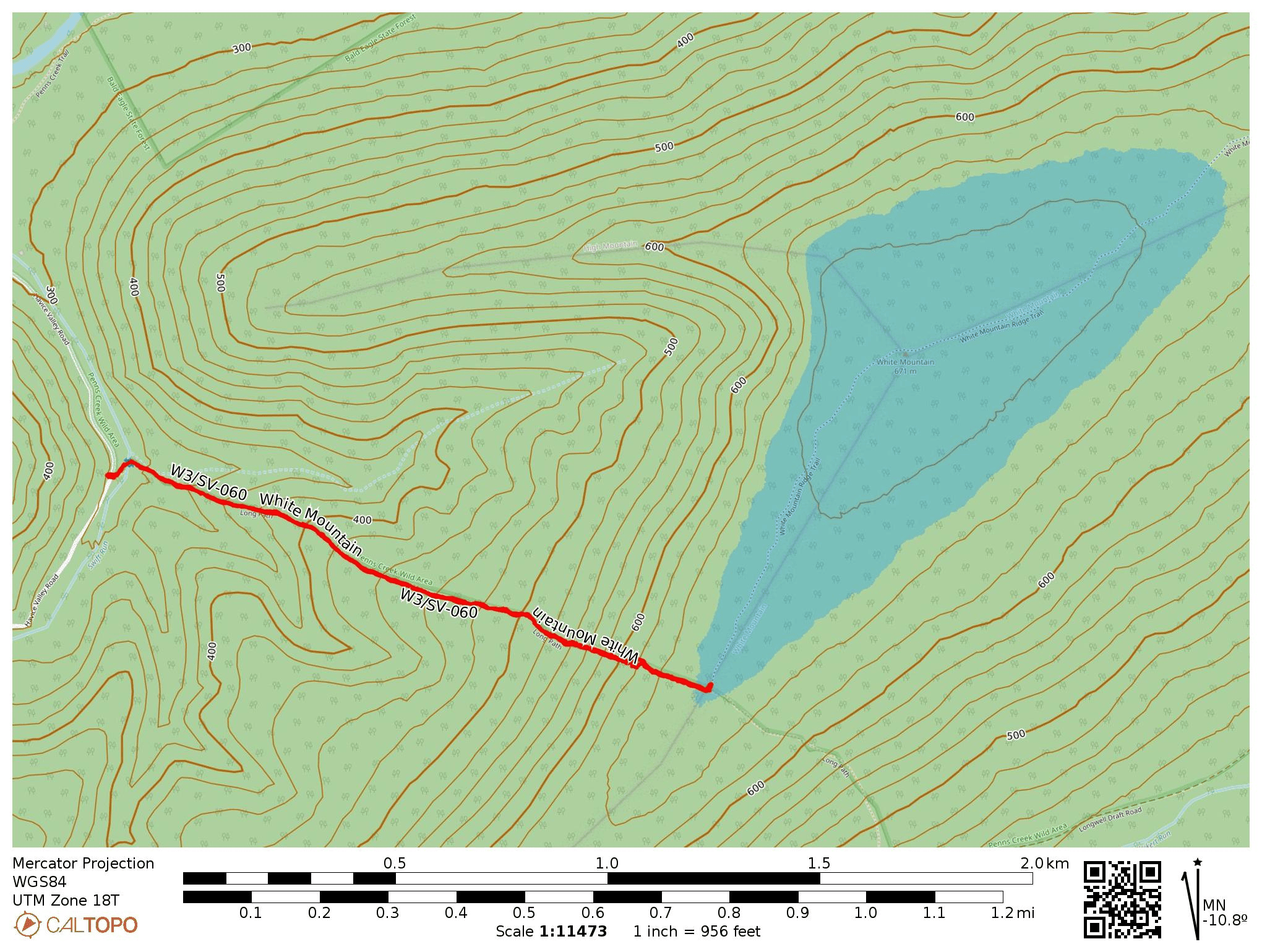
  • Trailhead: 40.82389, -77.40512 : A spot off the west side of Havice Valley road.
  • Map: [AA3TZ SOTA], some info on the area from Purple Lizard Maps
  • Route: 2.3 mile RT hike on Long Path, steep climb of 1100 ft into activation zone at junction of White Mountain Ridge Trail.
  • POTA: Bald Eagle State Forest (US-5462)

Then it was off to Reeds Gap State Park (US-1412) where I would camp for the night. I did a late-shift POTA activation, racking up 58 QSOs! By the morning, the coronal mass ejection finally arrived at earth, and the raging G8 geomagnetic storm scuttled my plans for a morning hike up Thick Mtn, W3/SV-022. I’ll be back!

W3/PW-029 Thick Mtn

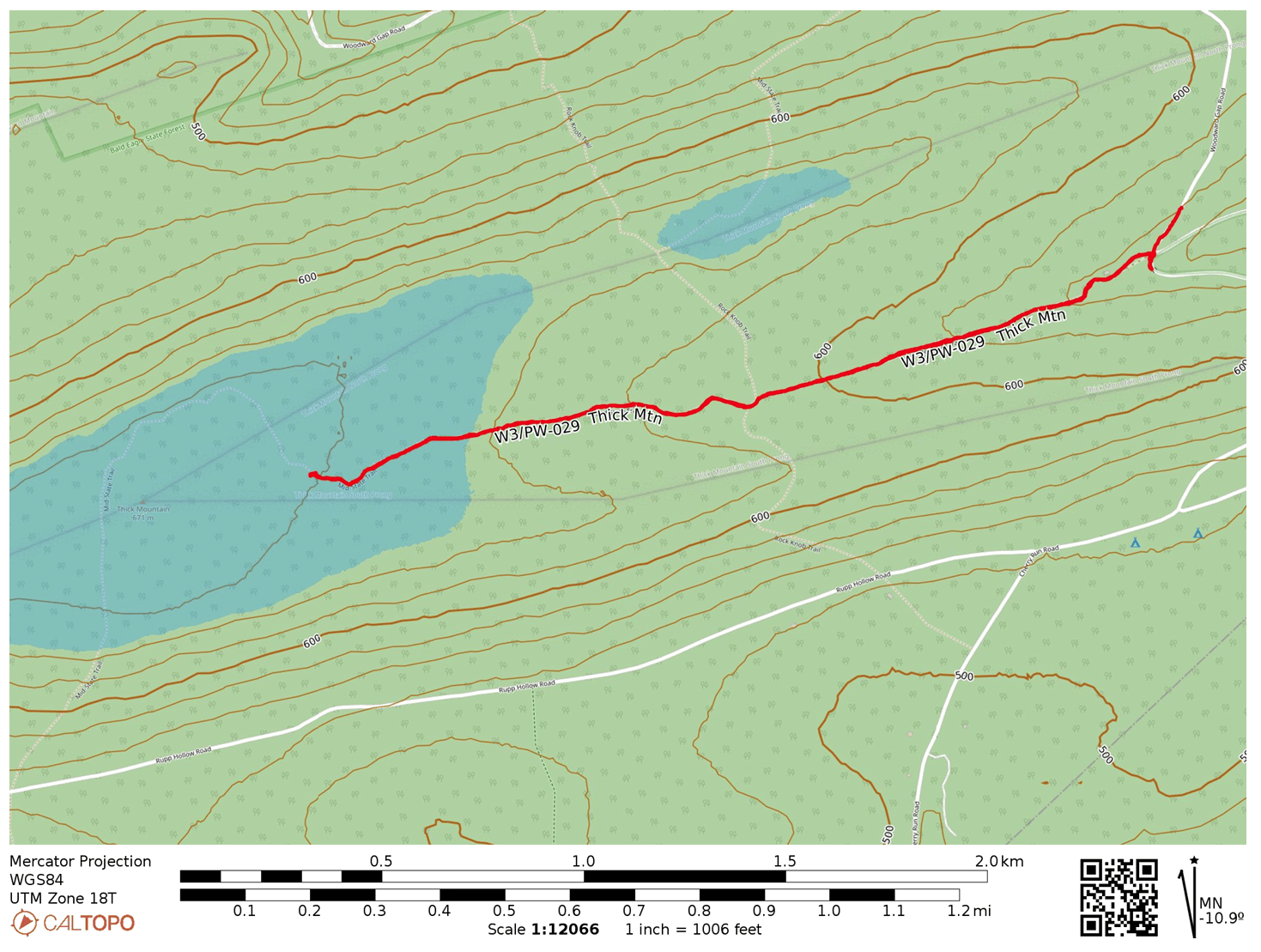
This second summit of the day in Bald Eagle State Forest was a short drive from W3/PW-024 Buffalo Mtn 2224. I parked near what Google Maps calls the Bear Run Natural Area, just north of the intersection of Bear Run Rd and Woodward Gap Rd. I found parking off the side of the road, but there is some space closer to the trailhead itself, which is right at the bridge crossing Bear Run. It was taken by a large truck today, but there is enough space for a few cars otherwise.

I hiked west along the the Bear Run Trail, which passes by a hunting cabin before continuing along the woods. The path starts out looking like a jeep track until you pass the hunting cabins, then turns into a hiking trail. It’s blazed in yellow, and about 0.6 miles in is a junction with the Mid-State Trail.

Here I continued west on the orange-blazed MST. The whole hike was a gradual climb of 400 feet over about 1.5 mi. As in the last hike, there was a lot of mountain laurel starting to flower. The trail was overgrown in places, but still easy enough to hike through. I did pass by a woman walking a friendly white lab, but those were the only other two hikers I saw. The activation zone covers a lot of the trail, but the tree cover is dense the entire way. I eventually found a spot I could step off trail to set something up.

This activation was subdued with some light rain. I did manage to work VA2EO on 40m, and a S2S with WN4AT on W4A/PT-004 Augusta Mine Ridge in AL. Be careful with ticks around here. I found a couple of them crawling on my leg as I was packing up.

  • Trailhead: 40.88637, -77.32471 : You can park right next to the trailhead if there is space, otherwise I found a spot off Woodward Gap Road at 40.88710, -77.32410 where NK8Q reports parking as well.
  • Map: [AA3TZ SOTA]
  • Route: 3.0 mile RT hike along Bear Run Trail and Mid-State Trail, 400 feet of gain
  • POTA: Bald Eagle State Forest (US-5462)

W3/PW-024 Buffalo Mtn 2224

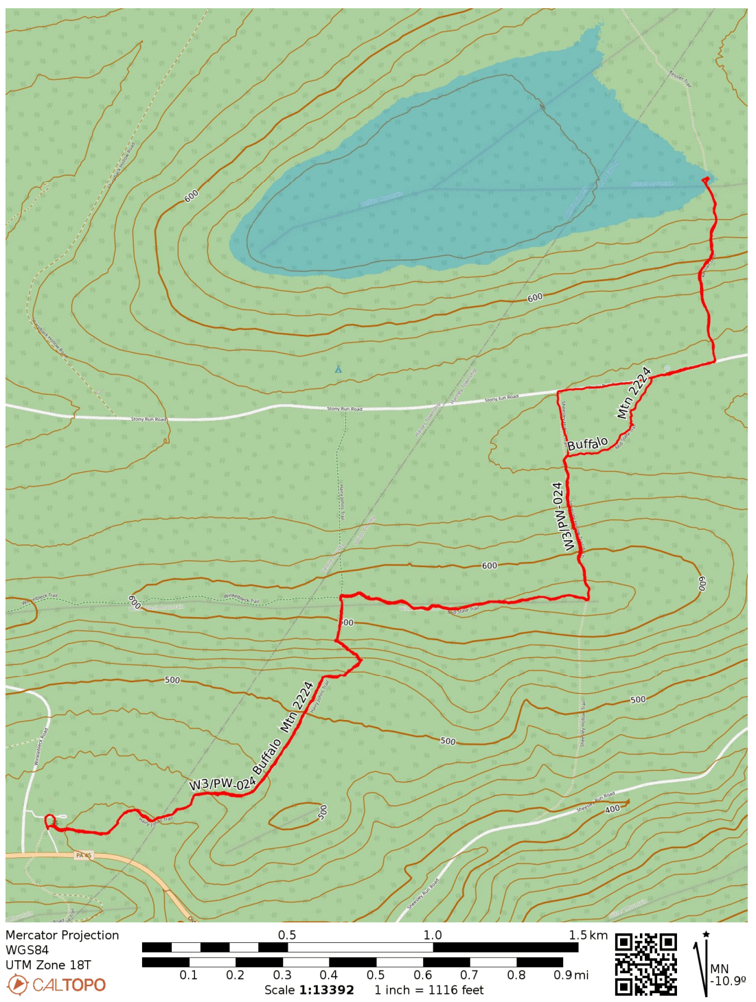
I went for three SOTA activations in Bald Eagle State Forest on Saturday, hoping to beat the impending arrival of a recent coronal mass ejection (which would come to destroy propagation and ultimately spark a G4 geomagnetic storm – yikes!). This peak can be done with a half-mile hike up a section of the Mid-State Trail, but I extended the hike to experience more of “Pennsylvania’s Wildest Trail,” which bisects the state. It is notoriously rocky, and I got to experience that here.

I started at Hairy Johns picnic area, where the Hairy Johns Trail takes over the MST and climbs up Winkleblech Mountain. The trail is well-marked with orange blazes. Mountain laurel was everywhere along the trail, and the pink buds were getting ready to burst open. At one point, the trail became a large boulder scramble. The boulders were slick with the previous night’s rain.

On top of this first hill, the MST leaves Hairy Johns Trail and follows the Winkleblech ridgeline east. This was the most pleasant part of the hike, featuring more mountain laurel and a nice breeze. There were a few pretty vistas through the trees on the way up as well. There was also a good place to camp along the trail for overnight hikers.

The trail descended along the north ridge. Near the bottom, the streams had swollen with recent rain, completely submerging the MST in places. After splashing through some pooled water, I made it to Stony Run Road, a gravel road where most other SOTA activators seem to have started their hike. There were plenty of places to park off the side of this road, and it would cut off a good chunk of the trip, leaving just the last 0.5-mile, 400-foot ascent along the Kessler Trail.

Getting to the actual peak would have required going through a dense bushwhack, but a roughly 200-foot section of the MST is just within the activation zone. I carefully strung my EFHW down the length of the trail. I was off to the side in case any other hikers came by, but none did.

My only DX was the legendary F4WBN on 20m. I didn’t linger too long, since I had a nearly 3-mile return hike, and there were other summits to activate today! On the way back, I avoided the swamp of the MST by walking west on Stony Run Road until I reached a jeep trail that passed by a cabin. I waved at the elderly man sitting on the cabin’s stoop. He agreed that the MST was totally drenched and understood why I was walking by his way. I managed to avoid getting my mostly-dried out feet wet once again, so that was a win!

Next up was W3/PW-029 Thick Mtn, the trailhead just about a 10 minute drive from Hairy Johns picnic area.

  • Trailhead: 40.91116, -77.28251 : A lot of parking in the Hairy Johns picnic area. There is plenty of parking along Stony Run Road, so you can just start at the Kessler Trail around 40.92515, -77.25533 for a shorter 1-mile RT hike.
  • Map: [AA3TZ SOTA]
  • Route: 5.8 mile RT hike along Mid-State Trail (Hairy Johns and Kessler Trail), 1400 feet of cumulative gain
  • POTA: Bald Eagle State Forest (US-5462)

W3/SV-001 Blue Knob via Lost Turkey Trail

Atop the second-highest peak in PA is a ski resort, making Blue Knob a drive-on. Since it’s the ski season, I wanted to stay away from the crowds and hike along the south face in Blue Knob State Park. I brought Luna along this time for her first SOTA activation, with the goal of hiking the Mountain View loop trail.

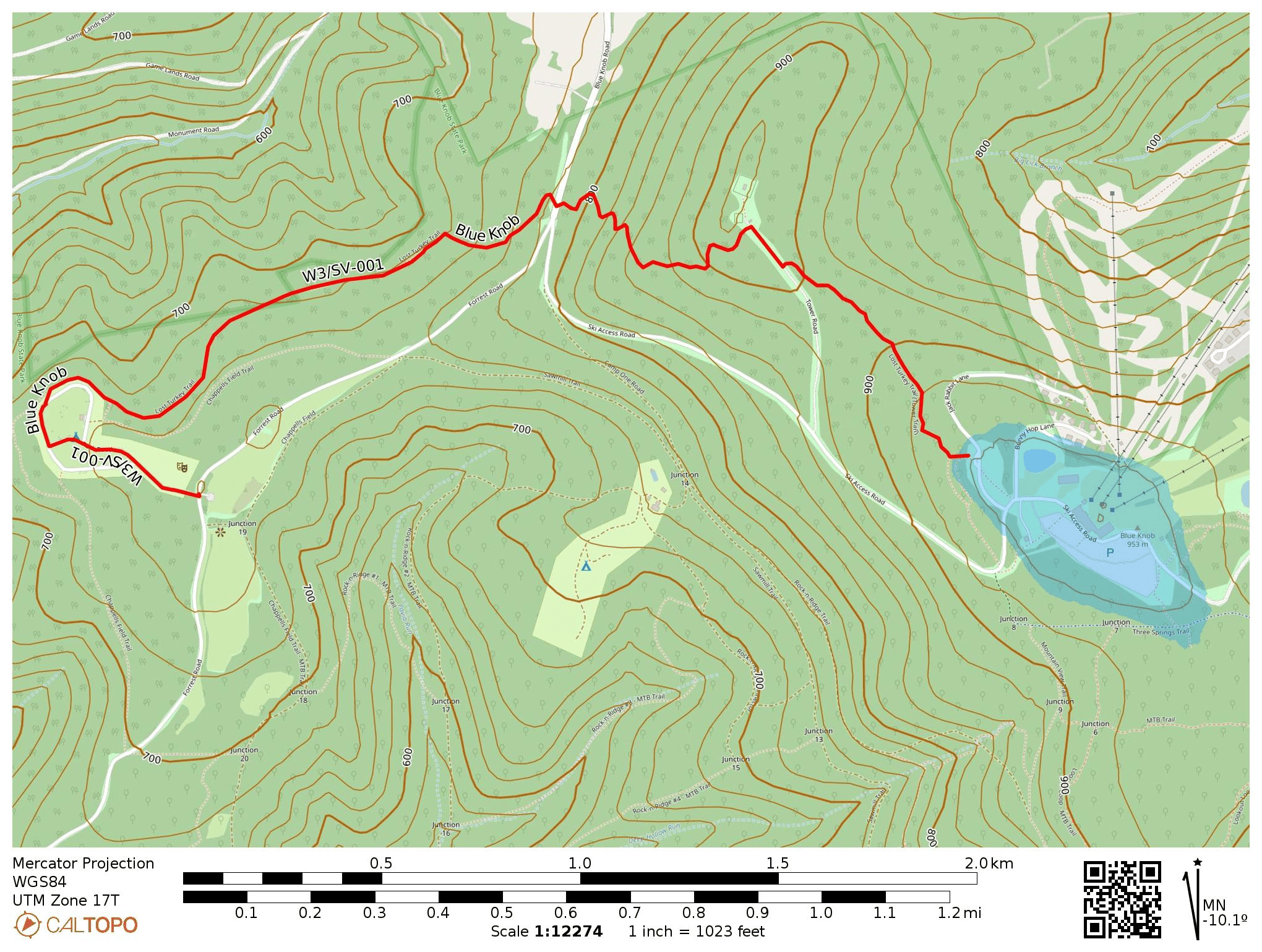
Park Road was closed off, likely due to snow, so we had to change plans. I continued up Forest Road to park at the Chappell’s Field Trailhead which has great views of the surrounding hills. A short walk through the family campground (gates were closed) got us to the Lost Turkey Trail, which is marked with red blazes and approaches the summit from the west. This trail was blazed by the Youth Conservation Corps in 1976. If we had gone west from here, we would have passed a monument for the Lost Children of the Alleghenies, memorializing two children who died in the wilderness around here in 1856.

There was about a foot of snow on the trail in some places, which made things trickier. Luna, only about 50 pounds, could walk on top of the hardened snow’s surface without leaving footprints, while I sunk right in with each step in places. She did enjoy diving into the snow when we found a soft spot. Adding snowshoes to the gear wishlist…

After about 700 feet of elevation gain, we made it to the northern terminus of Lost Turkey Trail, Herman Point. As is typical for PA peaks, there was a small collection of radio antennas here. Across the road was the Lost Turkey Trail Connector that continues on towards the ski resort. The trail’s entrance was hard to find, but is marked with a couple blue blazes. We lost the trail a few times in here, but our goal was just to get within the activation zone.

Last time I visited Blue Knob, I activated it by parking on Jack Rabbit Lane and walking down to this spot. This time, I hiked up from the west. Either way, it’s a good spot to operate while staying out of the way of skiiers.

I got a good 36 QSOs in 40 minutes, including a S2S with KC7WXD on Spanish Benchmark in Nevada (W7N/WC-084) and KB9ENS on Mount Lawlor in southern California (W6/CT-089). After waiting patiently for so long, Luna was happy to get back on the trail and jump through more snow. Blue Knob is an easy 10-pointer, one of only 4 in all of W3-SOTA. This trail was a great way to make activating it more of an adventure than a simple drive-on!

  • Trailhead: 40.28915, -78.58924 : Chappell’s Field Trailhead
  • Maps: [AA3TZ SOTA] [Blue Knob State Park Map]
  • Route: 4.8 mi out-and-back, following the Lost Turkey Trail and Connector Trail
  • POTA: Blue Knob State Park (US-1335)

W3/PD-001 Big Mtn

I wanted to add a second peak to my trip after bagging Snowy Mountain, but I was concerned about the building winter storm. AC3B’s trip report noted that the forest road leading to Big Mountain (the high point of the Tuscarora Mountain ridge) was wide and unexposed to steep cliffs, with plenty of opportunities to bail if needed. It also is within Buchanan State Forest, so this works as another SOTA/POTA special.

To get there, I drove west on US-30, then turned onto Augwick Rd. I followed this for a mile, then turned onto Tower Road, which is not maintained during winter and was covered in snow. I just had to take things slow and in low gear for the 2-mile drive to the summit, letting my Subaru’s AWD rise to the occasion. The road was double-track width, which was comforting (even though I didn’t pass anybody on the way up or down).

Tower Road looks like this the entire 2-mile drive up. Dear reader, the sign that says “No Winter Maintenance” was not lying! Still my low-clearance sedan with AWD made it with minimal slipping (going slow and low gear).

I parked along the small loop by the overlook and saw where the Tuscarora Trail continues north through the woods. The vista point must be great in clear weather, but all I could see today was a gray haze. I took in the view, setting up on the stone bench while opting to operate while standing. There was a security camera making sure that nobody would spray graffiti onto the rocks. By now, the flakes were coming down thick and making everything wet. I was thankful for the AX1’s rapid and painless set up.

I picked up 11 contacts in just about 15 minutes, including a S2S with WW4D on Cedar Creek Mountain (W4C/US-029). My notepad was starting to soak with the heavy precipitation and I decided to pack it in.

  • Trailhead: 39.92892, -77.95549 : The intersection of Augwick Road and Tower Road, just north of US-30
  • Map: [AA3TZ SOTA] – For the driving track along Tower Road
  • Route: Drive-on along 2-mile forest road (no winter maintenance, but relatively easy drive as forest roads go)
  • POTA: Buchanan State Forest (US-5463)

As I was leaving, this sign for Cowans Gap State Park beckoned me to continue north on Augwick Road for a POTA chaser, just 4 miles away. I set up in a picnic shelter near Parking Lot #2, not far from the park office. I could relax a bit and enjoy drier conditions for a bit.

Now that I’m accumulating PA state parks and forests, I feel like I should try to visit/activate them all: 124 parks and 20 forests!

W3/PD-007 Snowy Mountain

I went in Gettysburg, PA for a personal mini-retreat after the semester’s first week wrapped. A winter storm was coming through, so I tried to get an early start to tackle a group of SOTA/POTA sites. This my first time trying out the AX1 portable vertical antenna for quicker set up and pack up process than putzing around with my arborist’s throw line and end fed wire. Snowy Mountain in Michaux State Forest was first on the list.

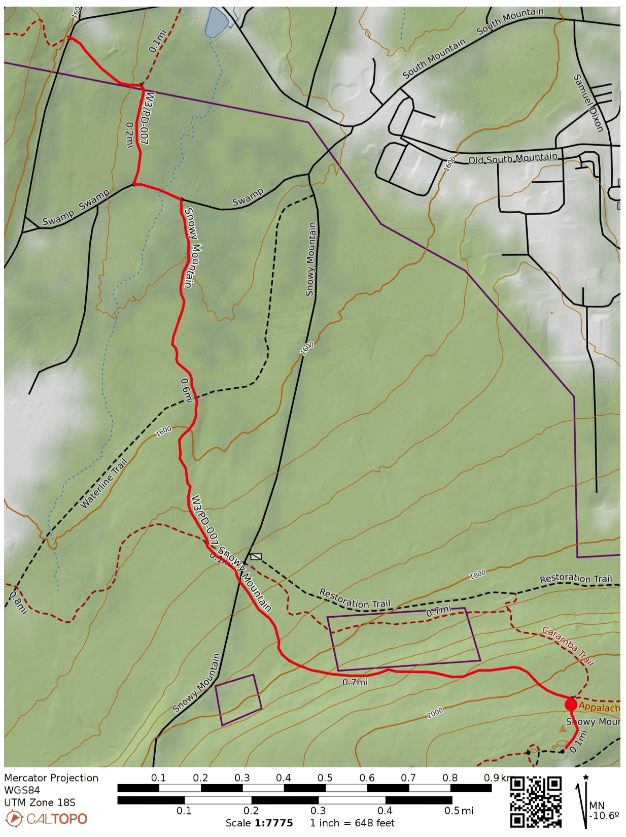
I did not want to drive up snowy forest roads, so I decided to hike in along the Appalachian Trail. I parked at the trailhead on PA 233, which has room for a couple cars. Shortly into the hike, the AT briefly continues along Swamp Rd, then winds on through the forest.

A runner mysteriously materialized, and somehow passed me twice during the 1.6 mile hike. I also saw a hawk carry a squirrel away for a meal. Other than those wildlife sightings, it was a serene and quiet winter hike.

The last half of the hike came with 500 feet of climb. At the end, a powerline cut crosses over with the AT, and a short segment of the Caramba Trail continues due south to the peak, where a couple radio towers stand. The trail appears to be just inside in the activation zone, but I opted to set up about 50 feet up the path to the summit where I found a rock to sit on. At this point, the snow was really coming down in large, wet flakes, so I was eager to get started.

The AX1 worked well! I was spotted quickly on 20m and made 11 contacts in about 20 minutes. By then, everything was starting to get wet and full of snow. Packing up was where the AX1 really shined, with the whole kit stowed away in just a couple minutes.

  • Trailhead: 39.84973, -77.50879 : Appalachian Trailhead Parking: PA 233 Rocky Mountain Rd
  • Maps: [AA3TZ SOTA] [Michaux State Forest Map]
  • Route: 3.2 mi out-and-back, following the Appalachian Trail
  • POTA: Appalachian National Scenic Trail (US-4556); Michaux State Forest (US-5471)

Mont Alto State Park (US-1386) is just over 3 miles down PA 233, so I added this POTA activation to the trip. Mont Alto is the oldest PA state park, and started (as many PA parks in this area) as an iron furnace. The main feature here was a large picnic pavilion (formerly a carousel house) that was an ideal place to set up. I worked this one a little longer due to the shelter keeping things dry, and logged 40 QSOs on 20m CW before calling it quits.

It was on to the next peak: Big Mountain.

W8V/PH-058 Backbone Mountain and Blackwater Falls State Park

We were staying in Davis, WV to see the leaves during our fall break in mid-October. It was colder than anticipated, and the area got its first snow of the season while we were there! Driving up to Backbone Mountain was simple. We followed US-48 west out of Davis until we reached a parking lot for Fred Long Centennial Park, with large wind turbines nearby. Here we pulled into the gravel road across from this parking spot and followed it the quarter-mile to the summit.

It was very foggy, so there was not much to look at while getting my end fed as high up as I could. After 15 QSOs on 40m and 20m, I had a look at the spotter and I noticed many European stations were on 10m, so I decided to give it a try. To my shock and delight, stations from Europe were booming in, and I was able to work 15 more stations in just over 10 minutes before the mini-pileup had dried up.

10m transatlantic contacts: F4WBN, EA4R, G3VXJ, DJ2MX, G3XBI, SQ9IDE, G4OBK, DL4FDM, and HA7WA

10 meters really is the magic band! I did not use it often when I was more active in SOTA in the Bay Area, as sunspots were on the downswing during those years (2015-2018). I was lucky to get back into the hobby during the peak of Cycle 25!

  • Trailhead: 39.14683, -79.57417 : Gravel road across US-48 from Fred Long Centennial Park
  • Map: [AA3TZ SOTA] – For the driving track
  • Route: Drive-on along quarter-mile gravel road
  • POTA: No, but close to Blackwater Falls State Park (US-1802)

Backbone Mountain is just 10 miles from Blackwater Falls State Park, so I added a POTA activation later that afternoon after the afternoon rain had cleared. I found a bench at the Pendleton Point Overlook to operate from and took in the glorious sights!

Other good spots in the park were Lindy Point Overlook and Gentle Trail to Blackwater Falls. Rhododendrons are everywhere, and it must be really amazing to be there when they’re blooming.

W3/PT-001 Mt Davis

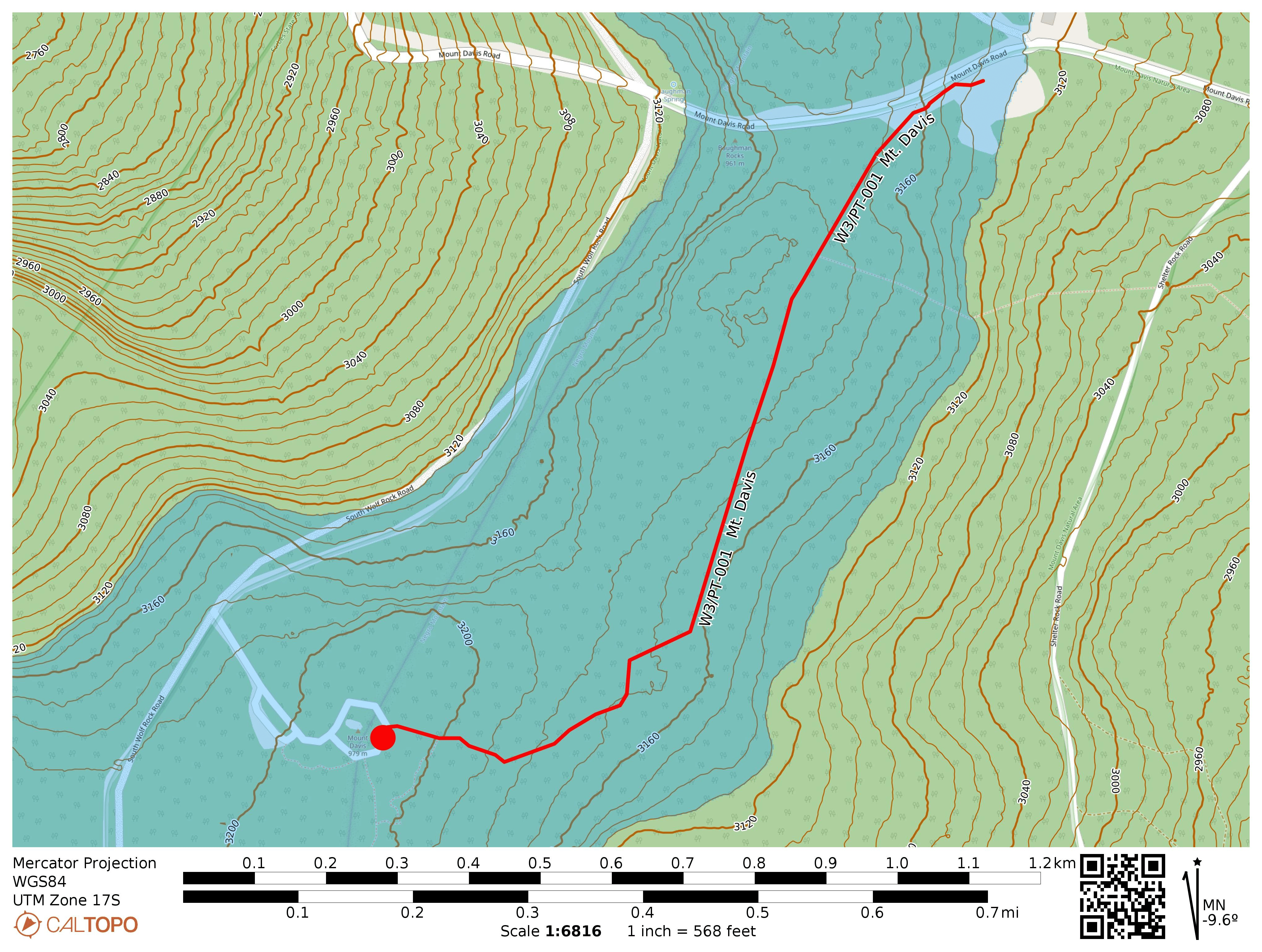
I had some time to drive up to Mt Davis on July 3 to see Pennsylvania’s high point at 3213 feet. This is the most activated SOTA peak in the W3 area, with my activation making it 125 to date. The summit is surrounded by the Mt Davis State Conservation Area (US-0625) which is also part of the Forbes State Forest (US-5468), making this a double-POTA activation.

While it’s possible to drive to within 300 feet of the peak, I opted to park at the High Point Picnic Area for a mile-long hike to the observation tower along the High Point Trail. This mostly-flat trail is part of a greater ~5 mile loop that tours this chunk of Forbes State Forest. I might try that loop next time.

I took the stairs up the observation tower and had a look around. Despite being the high point, Mt Davis is not particularly prominent, so the observation platform lets you see other ridges around the area. Once I was satisfied, set up near the paved loop by a stone pillar that was once a signpost. A disused trail spur entered the forest for about 40 feet or so, which was a perfect place to string up the end-fed. An easy way to earn 10 SOTA points!

  • Trailhead: 39.79417, -79.16653 : Northwest end of the Mt Davis Picnic Area.
  • Maps: [AA3TZ SOTA] [Mount Davis Area Map]
  • Route: 2.0 mi round trip, following the High Point Trail
  • POTA: Mt Davis State Conservation Area (US-0625); Forbes State Forest (US-5468)

Update 18 July 2025: This is a broad activation zone, as is typical for PA. The westernmost couple of benches in the Mt Davis Picnic Area are within the AZ! You can do this one POTA-style. I added this activation after completing Boardman Ridge, using the easy location as an opportunity to try my FT891 in the field; QRO for the first time!

The QSOs came in fast, but the rain came faster. I had to pause in the middle to wait for a break in the rain, then racked up a few more before the rain picked up again and forced me to pack up. 32 QSOs total, pieced together from two short runs punctuated by precipitation.

Update 14 Feb 2026: The Mt Davis picnic area makes for a great spot to do a winter activation. Deep snow engulfing the tables, but little wind. A couple of snowshoers visiting from Maryland passed by to ask about my setup. This time, I was using the Sotabeams 20-30-40 linked dipole and FT891 for QRO fun, logging 120 QSOs! Fun DX included Finland OH1MM and Iceland TF3DC, both on 20m!

W3/PT-007 Bear Cave Lookout

I recently changed my callsign from AI6CU to AA3TZ since I now live in PA, and was working the CQ WPX contest to break in the new callsign. I went on this hike to take a break from the contest and work my first SOTA with the new callsign. It took longer to drive to the trailhead than I expected, since the final approach is very bumpy. Bear Cave is large maze cave formation somewhere west of this 2600 ft peak. It looks like it gets very tight in there (https://www.youtube.com/watch?v=rFYwIoEOKV0).

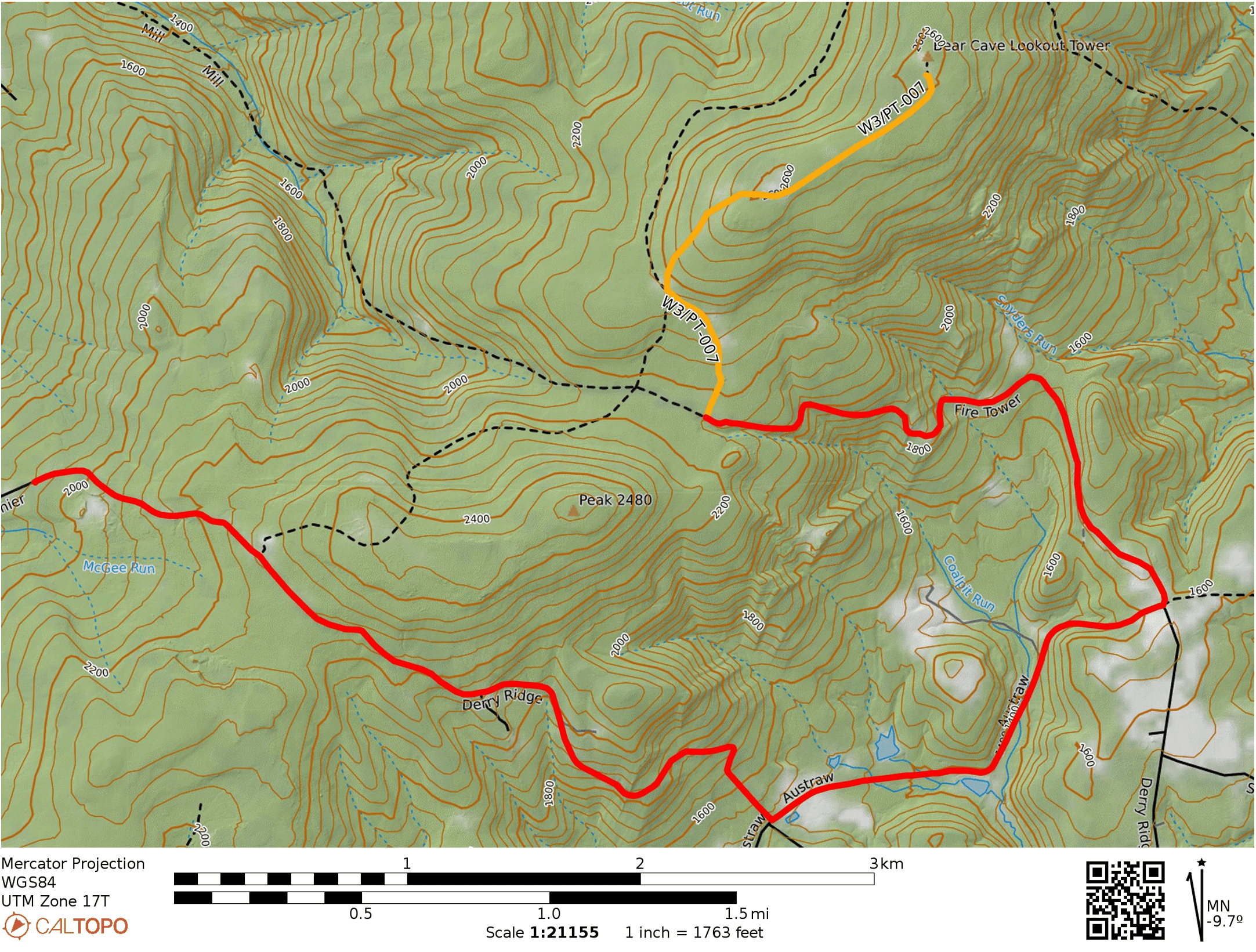
Google will try to take you down a trail that goes northeast from Derry Ridge Rd in Ligonier, but the road does not appear to exist. Continue along Derry Ridge Road, then turn northeast on Austraw Rd towards the intersection of Austraw Rd, Derry Ridge Rd, and Firetower Rd. Here, continue down Firetower Rd, which is a good gravel road for about a half mile, then becomes a bumpier dirt road for the remaining mile (starting around 1700 feet elevation). I had to go slow, but my sedan (Subaru Impreza) made it fine. It would probably not have gone well on a wet day. There is a small dirt parking spot at a locked gate with room for one vehicle. A truck was parked there so I parked a bit down the road where there was another pulloff.

Red marks the car route and Yellow marks the hike. Fire Tower Rd gets kind of rough about a half mile in for a sedan, but it’s fine on a dry day.

The first half of the 1.5-mile hike is a climb up 400 feet to a long, flat ridge. The rest of the hike follows a road that passes a large number of radio transmitters along this ridge. The road was flooded with 4 inches of water in places during this trip, but it was dry off the road. The observation tower at the peak was locked.

I set up by some rocks near the edge of the forest, but a couple of hikers suggested that I stay away from them as above 1600 ft elevation is where rattlesnakes live. “It would really suck to get bit by a rattlesnake out here,” one added. They were actually there to look for snakes and claimed that they had seen over 20, walking along the sun/shade line! Spooked, I moved into the sunny clearing and kept my eyes peeled. I heard intermittent noise on 40m, presumably from one of the nearby transmitters.

After the hike, I found the snake-fans by their truck, which was the one parked at the gate. They asked me some questions about CB radio, and I got them hyped up about the current peak in the solar cycle. I might come back in the winter, but I will probably just walk along Firetower road for a longer hike rather than drive on the rough road. Also, the snakes will be hibernating.

  • Trailhead: 40.33267, -79.23716 : Approach from Firetower Rd
  • Maps: [AA3TZ SOTA]
  • Route: 3.0 mi round trip, following trail towards and along multiple radio transmitter sites.

PA/PA-006 – Signaal Imbosch

It’s been a while since I’ve managed to write a blog post about a SOTA activation. Many things happened in my life – I moved to Pittsburgh, started a job as a professor, got married, bought a house, brought a puppy to the house… there just wasn’t much time for radio while I was doing my postdoc and then starting a new job in a new city. I feel like SOTA and POTA have changed quite a bit in that time as well, with a lot more activity and plenty more resources to help plan trips. In particular, sotadata got a glow-up, and sotl.as is just really nice to use.

Over spring break, I took a trip to the Netherlands, which has two SOTA peaks. I was staying in Utrecht, so I decided to go for Signaal Imbosch, which is in the Nationaal Park Veluwezoom, making this a POTA/SOTA activation. This would be my first SOTA activity in nearly 2 years, so I was rusty. And a bit nervous. My callsign for the trip was PA/AI6CU/P, which is definitely a keyful! It was a cool and dry day, in the mid-50s F, which Dutch folks were quick to tell me was fantastic weather for March.

I took the train from Utrecht to Arnhem with a rental e-bike. I needed to get a day-pass for my bike to use the train.

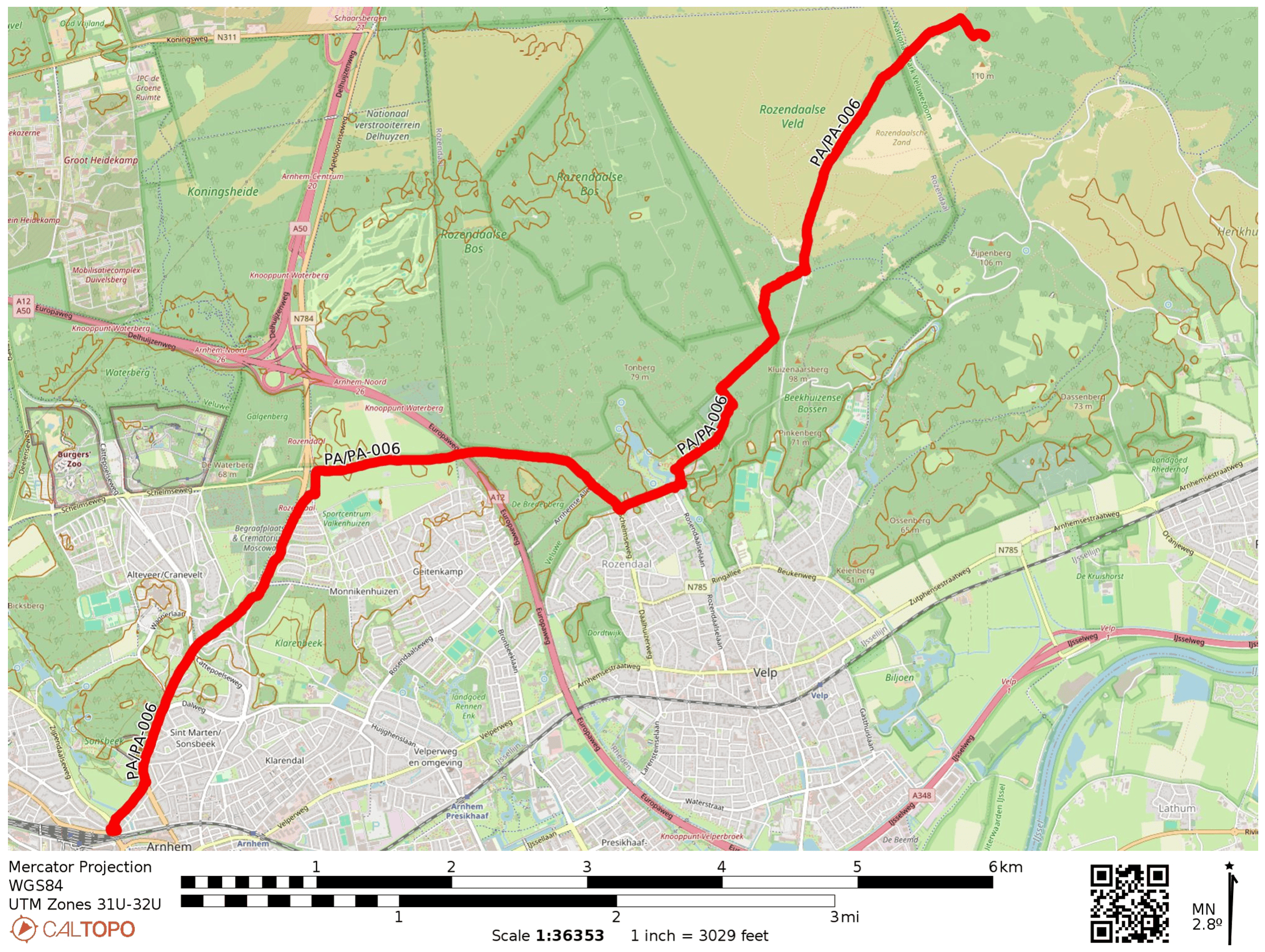
From Arnhem Station, I rode up to the park along and towards Signaal Imbosch, close to 7 miles with a few gradual climbs. Perhaps Velp would have been a better starting point, with a more direct path to the hill.

Biking around the Netherlands was a wonderful experience. I was surprised I was able to ride all throughout the Veluwezoom park, taking advantage of an extensive and well-signed network of bike paths.

Signaal Imbosch is the high point of the Veluwe natural area in the central Netherlands. During WWII, it was the site of a Luftwaffe aircraft monitoring radio station (Teerose II), and there are some remains of the site here.

Having finally reached the hill, I got my end fed mounted to my 21-foot pole (though there were plenty of trees around). The soil was sandy, and the landscape reminded me of the Pine Barrens in New Jersey.

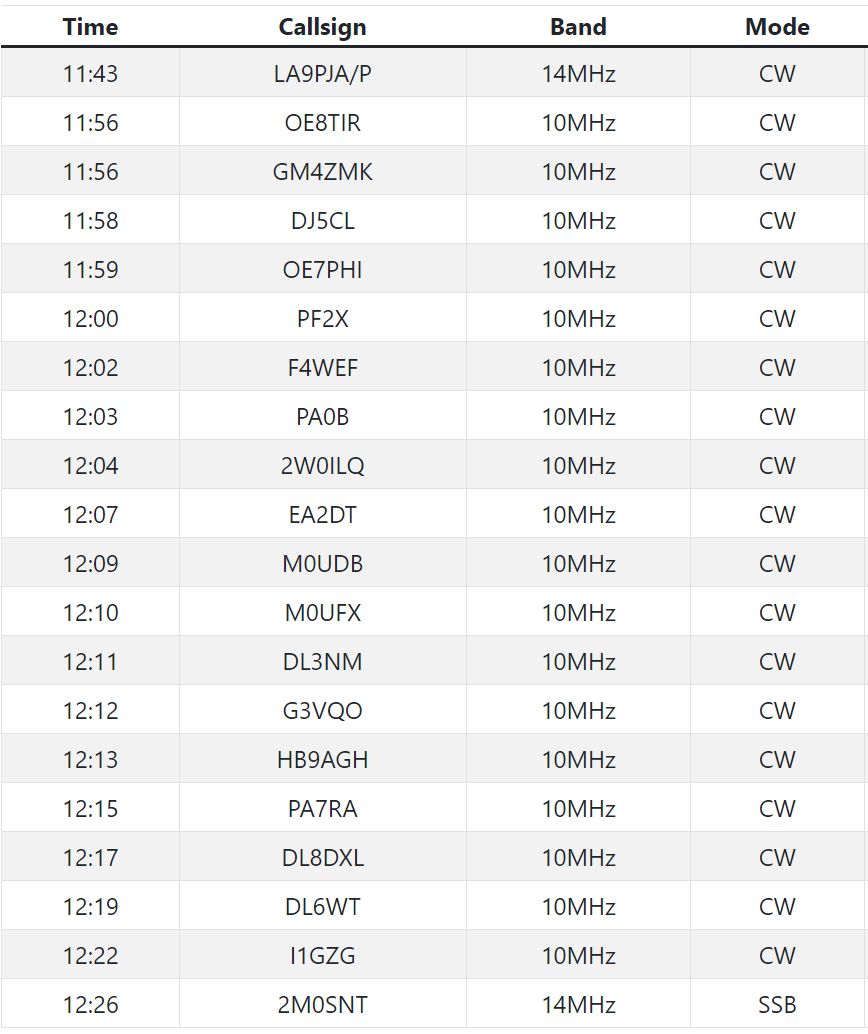
In a sign of my rustiness, I tuned my wire on 30 meters, which is not a band it is resonant on (oof!). Still, I managed to get myself spotted with cell service and quickly got contacts from around Europe. All sorts of new (to me) prefixes!

2M0SNT, who was working a POTA station awarded me the “longest callsign of the day” award. Thanks to all the chasers!

Afterwards, I rode over to the Kröller-Müller Museum in the nearby Hoge Veluwe National Park (had to pay an entry fee for this park) to enjoy the extensive Van Gogh collection in a beautiful location.

I rolled back to Arnhem station and (feeling tired and saddle-sore after about 35 miles of riding), rode the train back to Utrecht. What a wonderful way to break the SOTA hiatus!