W3/SV-060 White Mountain

White Mountain has only been activated twice before, by two prolific W3 activators NK8Q and W3QP. It’s probably because of how strenuous the climb is, though I found the activation itself to be more pleasant than the one I just finished, W3/PW-029 Thick Mtn. Driving to this last hike of the day required me to drive past Poe Valley State Park and Poe Paddy State Park in succession along the scenic Penns Creek, which is evidently prime for trout fishing. These looked like nice parks to overnight in, so I’ll definitely be back to the area.

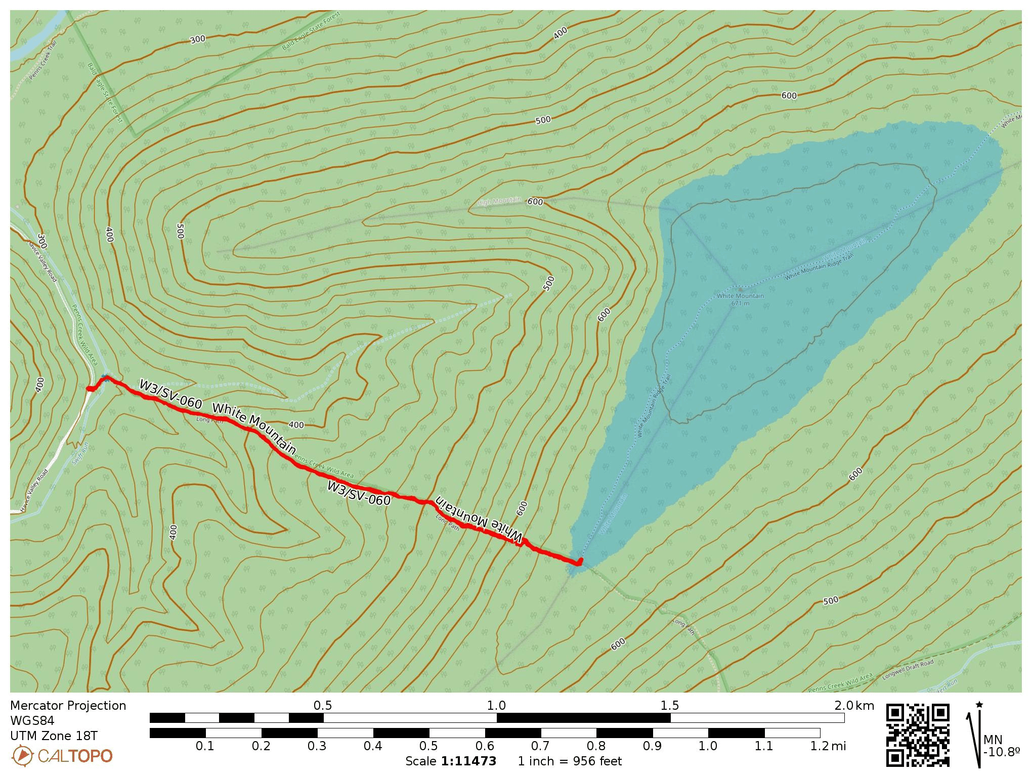
I parked at Havice Valley Road about 1.2 miles down the road from Poe Paddy State Park, as reported by W3QP. Here off the side of the road there was room for 2-3 cars to park, across from the driveway for a cabin. A short walk down this driveway is a bouncy suspension bridge over Swift Run, which continues as Long Path trail along the edge of Peens Creek Wild Area, marked with yellow blazes.

Before long, the hike became a relentless uphill trudge. The first 3/4 of a mile was not too bad, with an average grade of 15-20%. Then, things got ridiculous for the last 1/3 of a mile, with 400 feet of scrambling up a steep boulder field, over 50% grade at times. This was a slog, especially after having done 9 tough, rocky miles throughout the day so far, but coming at it fresh would have been all right.

Once I made it to the junction with the red-blazed White Mountain Ridge Trail, which continues northeast to the summit, I stopped to set up. I did this rather than continue up to the summit because I was now in the activation zone, I was tired, and the trail that way looked overgrown. It was also getting just a couple hours to sunset, so I was eager to get the QSOs rolling.

I had accidentally left my notepad in the car (doh!), so this was my first time using logging software in the field, Ham2K PoLo. I actually enjoyed the experience, and liked how it brought up each chaser’s name. I don’t like entering callsigns on a phone keyboard, but that’s more of a me problem. VA2EO was my only DX, yet again.

I packed things up, then descended slowly. Bring poles! I didn’t, and I fell, accidentally dropping my phone without noticing. I had to come back for it, which was a heartbreaking climb scanning through the boulder fields. Luckily, I did find it after about 10 minutes of searching.
  • Trailhead: 40.82389, -77.40512 : A spot off the west side of Havice Valley road.
  • Map: [AA3TZ SOTA], some info on the area from Purple Lizard Maps
  • Route: 2.3 mile RT hike on Long Path, steep climb of 1100 ft into activation zone at junction of White Mountain Ridge Trail.
  • POTA: Bald Eagle State Forest (US-5462)

Then it was off to Reeds Gap State Park (US-1412) where I would camp for the night. I did a late-shift POTA activation, racking up 58 QSOs! By the morning, the coronal mass ejection finally arrived at earth, and the raging G8 geomagnetic storm scuttled my plans for a morning hike up Thick Mtn, W3/SV-022. I’ll be back!

W3/PW-024 Buffalo Mtn 2224

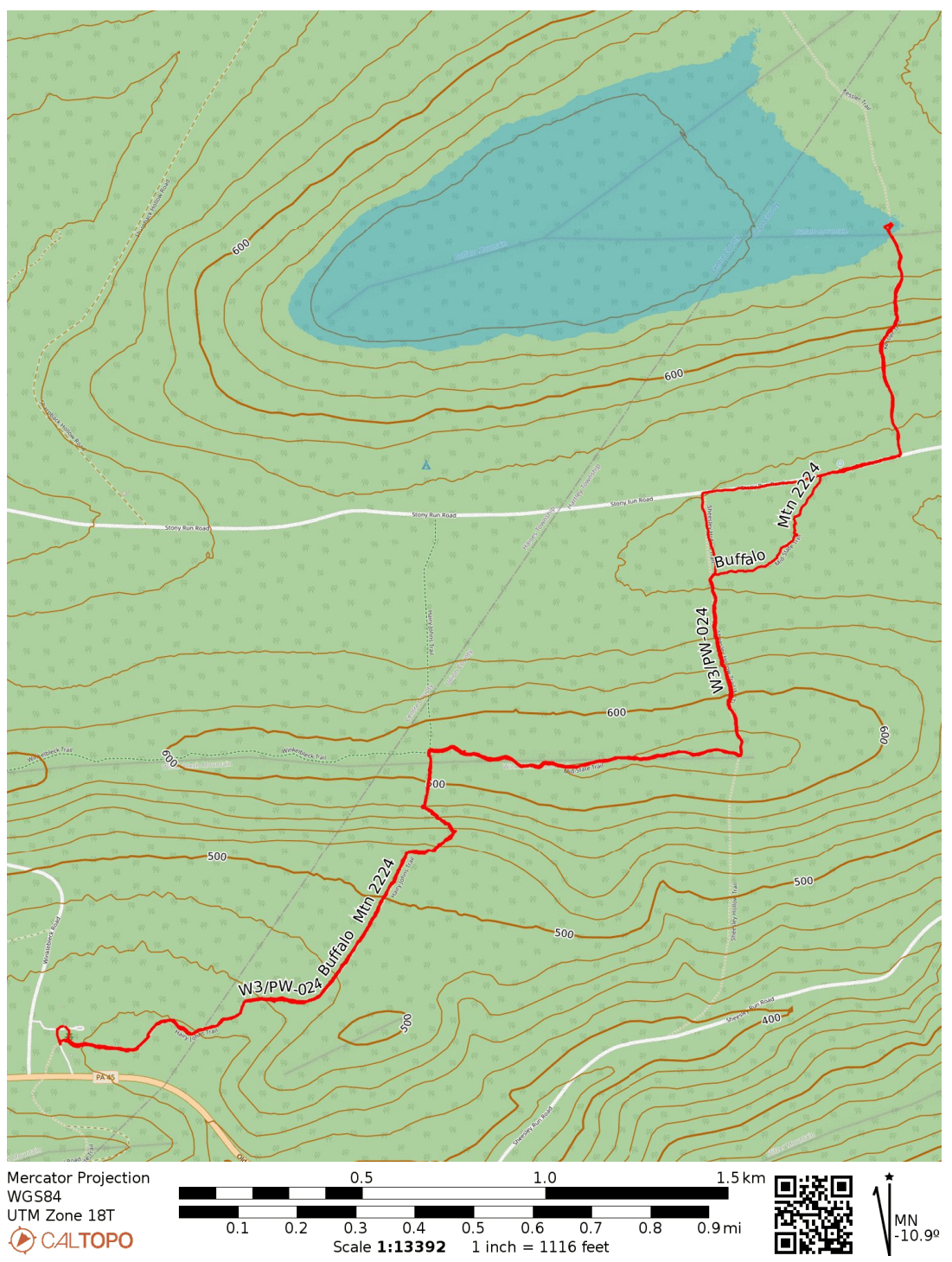
I went for three SOTA activations in Bald Eagle State Forest on Saturday, hoping to beat the impending arrival of a recent coronal mass ejection (which would come to destroy propagation and ultimately spark a G4 geomagnetic storm – yikes!). This peak can be done with a half-mile hike up a section of the Mid-State Trail, but I extended the hike to experience more of “Pennsylvania’s Wildest Trail,” which bisects the state. It is notoriously rocky, and I got to experience that here.

I started at Hairy Johns picnic area, where the Hairy Johns Trail takes over the MST and climbs up Winkleblech Mountain. The trail is well-marked with orange blazes. Mountain laurel was everywhere along the trail, and the pink buds were getting ready to burst open. At one point, the trail became a large boulder scramble. The boulders were slick with the previous night’s rain.

On top of this first hill, the MST leaves Hairy Johns Trail and follows the Winkleblech ridgeline east. This was the most pleasant part of the hike, featuring more mountain laurel and a nice breeze. There were a few pretty vistas through the trees on the way up as well. There was also a good place to camp along the trail for overnight hikers.

The trail descended along the north ridge. Near the bottom, the streams had swollen with recent rain, completely submerging the MST in places. After splashing through some pooled water, I made it to Stony Run Road, a gravel road where most other SOTA activators seem to have started their hike. There were plenty of places to park off the side of this road, and it would cut off a good chunk of the trip, leaving just the last 0.5-mile, 400-foot ascent along the Kessler Trail.

Getting to the actual peak would have required going through a dense bushwhack, but a roughly 200-foot section of the MST is just within the activation zone. I carefully strung my EFHW down the length of the trail. I was off to the side in case any other hikers came by, but none did.

My only DX was the legendary F4WBN on 20m. I didn’t linger too long, since I had a nearly 3-mile return hike, and there were other summits to activate today! On the way back, I avoided the swamp of the MST by walking west on Stony Run Road until I reached a jeep trail that passed by a cabin. I waved at the elderly man sitting on the cabin’s stoop. He agreed that the MST was totally drenched and understood why I was walking by his way. I managed to avoid getting my mostly-dried out feet wet once again, so that was a win!

Next up was W3/PW-029 Thick Mtn, the trailhead just about a 10 minute drive from Hairy Johns picnic area.

  • Trailhead: 40.91116, -77.28251 : A lot of parking in the Hairy Johns picnic area. There is plenty of parking along Stony Run Road, so you can just start at the Kessler Trail around 40.92515, -77.25533 for a shorter 1-mile RT hike.
  • Map: [AA3TZ SOTA]
  • Route: 5.8 mile RT hike along Mid-State Trail (Hairy Johns and Kessler Trail), 1400 feet of cumulative gain
  • POTA: Bald Eagle State Forest (US-5462)

W8V/PH-058 Backbone Mountain and Blackwater Falls State Park

We were staying in Davis, WV to see the leaves during our fall break in mid-October. It was colder than anticipated, and the area got its first snow of the season while we were there! Driving up to Backbone Mountain was simple. We followed US-48 west out of Davis until we reached a parking lot for Fred Long Centennial Park, with large wind turbines nearby. Here we pulled into the gravel road across from this parking spot and followed it the quarter-mile to the summit.

It was very foggy, so there was not much to look at while getting my end fed as high up as I could. After 15 QSOs on 40m and 20m, I had a look at the spotter and I noticed many European stations were on 10m, so I decided to give it a try. To my shock and delight, stations from Europe were booming in, and I was able to work 15 more stations in just over 10 minutes before the mini-pileup had dried up.

10m transatlantic contacts: F4WBN, EA4R, G3VXJ, DJ2MX, G3XBI, SQ9IDE, G4OBK, DL4FDM, and HA7WA

10 meters really is the magic band! I did not use it often when I was more active in SOTA in the Bay Area, as sunspots were on the downswing during those years (2015-2018). I was lucky to get back into the hobby during the peak of Cycle 25!

  • Trailhead: 39.14683, -79.57417 : Gravel road across US-48 from Fred Long Centennial Park
  • Map: [AA3TZ SOTA] – For the driving track
  • Route: Drive-on along quarter-mile gravel road
  • POTA: No, but close to Blackwater Falls State Park (US-1802)

Backbone Mountain is just 10 miles from Blackwater Falls State Park, so I added a POTA activation later that afternoon after the afternoon rain had cleared. I found a bench at the Pendleton Point Overlook to operate from and took in the glorious sights!

Other good spots in the park were Lindy Point Overlook and Gentle Trail to Blackwater Falls. Rhododendrons are everywhere, and it must be really amazing to be there when they’re blooming.