W3/SV-001 Blue Knob via Lost Turkey Trail

Atop the second-highest peak in PA is a ski resort, making Blue Knob a drive-on. Since it’s the ski season, I wanted to stay away from the crowds and hike along the south face in Blue Knob State Park. I brought Luna along this time for her first SOTA activation, with the goal of hiking the Mountain View loop trail.

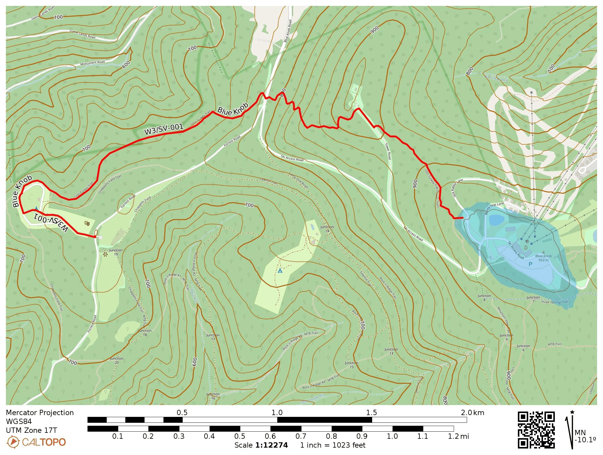
Park Road was closed off, likely due to snow, so we had to change plans. I continued up Forest Road to park at the Chappell’s Field Trailhead which has great views of the surrounding hills. A short walk through the family campground (gates were closed) got us to the Lost Turkey Trail, which is marked with red blazes and approaches the summit from the west. This trail was blazed by the Youth Conservation Corps in 1976. If we had gone west from here, we would have passed a monument for the Lost Children of the Alleghenies, memorializing two children who died in the wilderness around here in 1856.

There was about a foot of snow on the trail in some places, which made things trickier. Luna, only about 50 pounds, could walk on top of the hardened snow’s surface without leaving footprints, while I sunk right in with each step in places. She did enjoy diving into the snow when we found a soft spot. Adding snowshoes to the gear wishlist…

After about 700 feet of elevation gain, we made it to the northern terminus of Lost Turkey Trail, Herman Point. As is typical for PA peaks, there was a small collection of radio antennas here. Across the road was the Lost Turkey Trail Connector that continues on towards the ski resort. The trail’s entrance was hard to find, but is marked with a couple blue blazes. We lost the trail a few times in here, but our goal was just to get within the activation zone.

Last time I visited Blue Knob, I activated it by parking on Jack Rabbit Lane and walking down to this spot. This time, I hiked up from the west. Either way, it’s a good spot to operate while staying out of the way of skiiers.

I got a good 36 QSOs in 40 minutes, including a S2S with KC7WXD on Spanish Benchmark in Nevada (W7N/WC-084) and KB9ENS on Mount Lawlor in southern California (W6/CT-089). After waiting patiently for so long, Luna was happy to get back on the trail and jump through more snow. Blue Knob is an easy 10-pointer, one of only 4 in all of W3-SOTA. This trail was a great way to make activating it more of an adventure than a simple drive-on!
  • Trailhead: 40.28915, -78.58924 : Chappell’s Field Trailhead
  • Maps: [AA3TZ SOTA] [Blue Knob State Park Map]
  • Route: 4.8 mi out-and-back, following the Lost Turkey Trail and Connector Trail
  • POTA: Blue Knob State Park (US-1335)

W3/PT-007 Bear Cave Lookout

I recently changed my callsign from AI6CU to AA3TZ since I now live in PA, and was working the CQ WPX contest to break in the new callsign. I went on this hike to take a break from the contest and work my first SOTA with the new callsign. It took longer to drive to the trailhead than I expected, since the final approach is very bumpy. Bear Cave is large maze cave formation somewhere west of this 2600 ft peak. It looks like it gets very tight in there (https://www.youtube.com/watch?v=rFYwIoEOKV0).

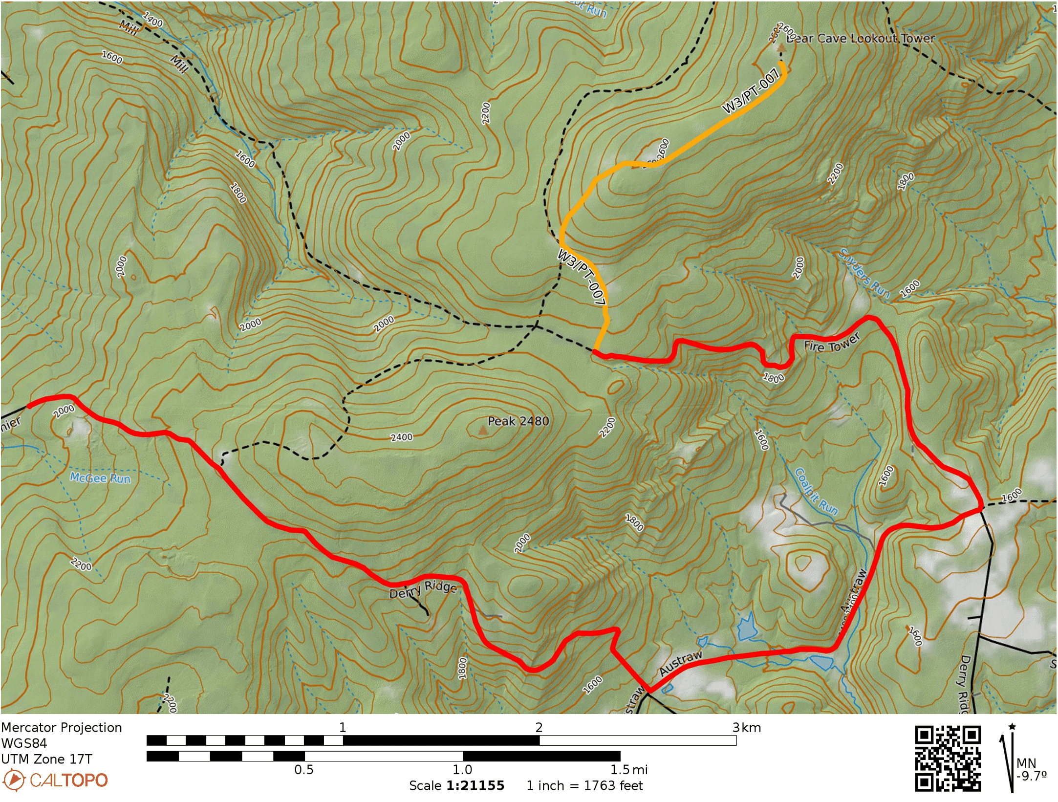
Google will try to take you down a trail that goes northeast from Derry Ridge Rd in Ligonier, but the road does not appear to exist. Continue along Derry Ridge Road, then turn northeast on Austraw Rd towards the intersection of Austraw Rd, Derry Ridge Rd, and Firetower Rd. Here, continue down Firetower Rd, which is a good gravel road for about a half mile, then becomes a bumpier dirt road for the remaining mile (starting around 1700 feet elevation). I had to go slow, but my sedan (Subaru Impreza) made it fine. It would probably not have gone well on a wet day. There is a small dirt parking spot at a locked gate with room for one vehicle. A truck was parked there so I parked a bit down the road where there was another pulloff.

Red marks the car route and Yellow marks the hike. Fire Tower Rd gets kind of rough about a half mile in for a sedan, but it’s fine on a dry day.

The first half of the 1.5-mile hike is a climb up 400 feet to a long, flat ridge. The rest of the hike follows a road that passes a large number of radio transmitters along this ridge. The road was flooded with 4 inches of water in places during this trip, but it was dry off the road. The observation tower at the peak was locked.

I set up by some rocks near the edge of the forest, but a couple of hikers suggested that I stay away from them as above 1600 ft elevation is where rattlesnakes live. “It would really suck to get bit by a rattlesnake out here,” one added. They were actually there to look for snakes and claimed that they had seen over 20, walking along the sun/shade line! Spooked, I moved into the sunny clearing and kept my eyes peeled. I heard intermittent noise on 40m, presumably from one of the nearby transmitters.

After the hike, I found the snake-fans by their truck, which was the one parked at the gate. They asked me some questions about CB radio, and I got them hyped up about the current peak in the solar cycle. I might come back in the winter, but I will probably just walk along Firetower road for a longer hike rather than drive on the rough road. Also, the snakes will be hibernating.

  • Trailhead: 40.33267, -79.23716 : Approach from Firetower Rd
  • Maps: [AA3TZ SOTA]
  • Route: 3.0 mi round trip, following trail towards and along multiple radio transmitter sites.