

At Xenia Hamvention this year, I met Mike AD8IS at the SOTA gathering. We were talking about the idiosyncrasies of SOTA activations in Ohio, which is a very flat state, and traded notes we had on Staley Knob, a not-yet-activated summit south of Chillicothe very close to a segment of the statewide Buckeye Trail. We were both eyeing the first activation and agreed to join forces for it, planning to regroup in August.
This portion of Buckeye Trail, part of the Sinking Springs section, passes along an easement through Cave Lake Camp, a privately owned campground that is part of the OH-WV Youth Leadership Association. Staley Knob is about half a mile north of the BT, connected by a saddle ridge to Smith Hill which the trail climbs along. Mike and I tried to determine if the AZ might reach along this saddle to include the BT, which led me to pore over LiDAR point clouds and DEM maps in a way I had never done before.
I learned a lot about LiDAR and was surprised to learn that the state of OH is very well-surveyed, being the first state to be completely mapped in 2007, following a state-sponsored survey, the OSIP. An updated USGS survey was completed between 2019-2023 as part of the federal 3DEP (3D Elevation Program). According to the latest and highest resolution 1-meter survey, it appeared that the very peak of Staley Knob is about 1275 feet, not the 1270 feet listed in the SOTA database (perhaps due to rounding to the nearest contour line from some earlier survey, but I’m not sure). The key col between Smith Hill and Staley Knob was tantalizingly close to staying within a 25m contour, but we were talking about maybe 2 meters of margin. Is LiDAR that accurate? I am starting to believe it might be, with some caveats!
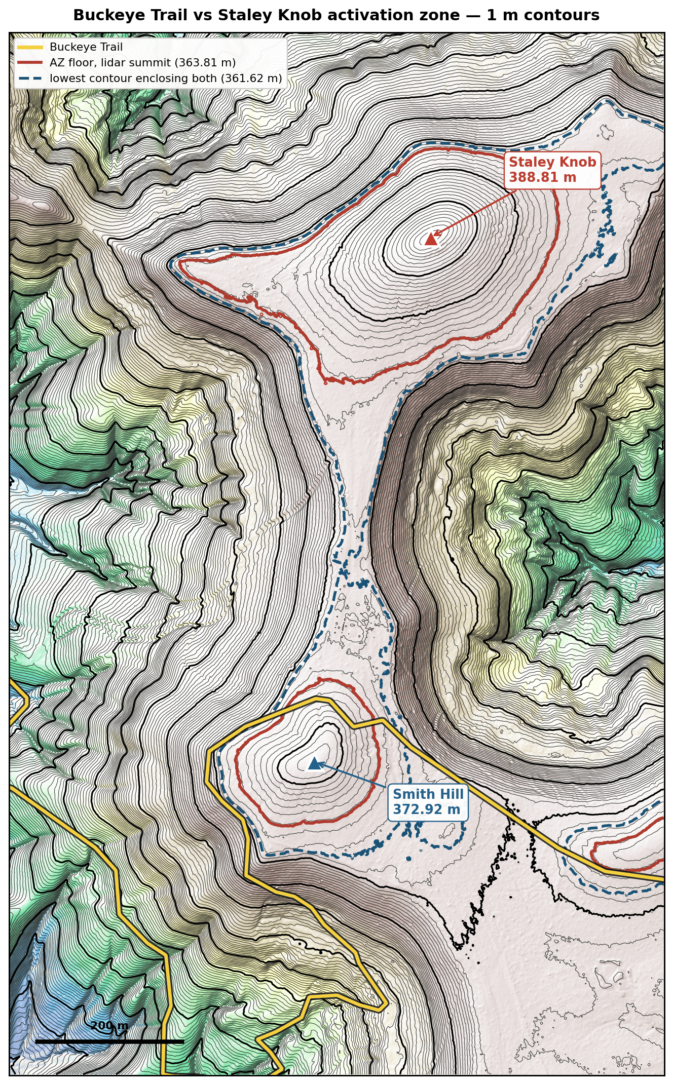
Mike covered a bunch of sources of error that might creep into LiDAR data, particularly over vegetated land like the forest surrounding Staley Knob. The 1 meter DEM are processed from raw LiDAR point clouds that record the time of last arrival over roughly 1 meter horizontal areas. If there is heavy brush on the ground preventing any light from striking the floor, some inaccuracies may be recorded. If such brush were present on the peak and resulted in a 2 meter overestimation of the summit, then there is some uncertainty that might push the activation zone further down towards Smith Hill. The USGS 3DEP specification for the OH survey that included this area cited a quality level of up to 30 cm VVA (vegetated vertical accuracy) at the 95th percentile. That means there are some areas, 5% of independent preselected quality checkpoints, have an absolute error greater than 30 cm. So in vegetated terrain, errors are not normally distributed. That makes sense, because vegetation on the ground can only add error to the estimated ground elevation, and this will skew towards outliers over areas with large amounts of plant matter/detritus covering the ground.


All this is to say that I was getting a little nervous about the probability that the BT was in the Staley Knob AZ. I felt that maybe any error or overestimation at the peak might also be added to the col, raising both together and not changing the AZ boundaries much. The only way I could see this (as a skeptical non-expert) working out is if the survey managed to both overestimate the summit (outside the 95th percentile) while also getting an accurate measure of the key col. Plausible, but I wanted something a bit more firm.
We were doing this analysis because Mike had trouble getting in contact with Cave Lake Park with the number posted on their Facebook page. As a last ditch effort, I rang the OH-WV YLA headquarters and got in contact with somebody who gave me another cell number for Sonny, the manager. This actually worked, and I was able to secure permission from Sonny just a couple days before our planned activation date. Our analysis was an interesting exercise, but now thankfully moot as far as this activation was concerned.
Sonny’s actually a licensed ham, though not currently an active one, and is fine with SOTA activators going to Staley Knob, provided that 1) it is not a hunting season and 2) he is notified ahead of time. There are a large number of hunting stands around the Cave Lake property, so avoiding the off-trail area during hunting season is a safety issue. You can reach out to me for Sonny’s number. He told us to park in front of a red gate where the BT transitions from a road walk to the Cave Lake property, proceeding east on the BT for a shorter approach. There doesn’t appear to be an official parking spot this close to Staley Knob.
Mike AD8IS and I met up in Pike Lake State Park (POTA US-1983) the evening before and did a night time activation of the park while going over plans. We passed his FX-4CR back and forth, which would be how we would end up operating on the knob the next day. There was forecasted rain that was to hit around noon, so we wanted to get going early in the morning if possible.
We parked in front of the red gate on the side of Bell Hollow Road (39.10312, -83.34455). The gate is closed but not locked, and the blue blazes for the BT mark that this is where the trail continues on from the road. We were able to just fit my subcompact SUV and Mike’s pickup in front of the gate, but it was tight. Worth mentioning some photo credits: any photos that look like they were not taken with a mixture of petroleum jelly and sweat on the camera lens, those would be Mike AD8IS’s pictures! The rest are mine.


The trail was a bit overgrown along this first part, as expected for this time of year. Sonny did warn me that it would be pretty rough going. We passed a couple of massive anthills.


Before long, we were in the forest. The BT was more clear and wound through the trees, and the hike became more enjoyable. At some point, we came across some small animal’s (deer calf?) bones on the trail.


At just about the 2 mile mark, we made it to Smith Hill and were ready to walk across to Staley Knob. Don’t turn too quickly like we did at first. There is a really nice ATV clearing (or “deer highway”) that crosses the BT that takes you directly to the knob, avoiding the worst bushwhacking. Staley Knob rises from the other side, and is semi-open. There is definitely stuff on the ground that LiDAR may have had trouble with, but we were able to get right to the peak which felt good.


We started the activation with a 2m CW QSO to get AD8IS into the ranks of BKG, and also to get points for the 2026 SOTA 2m Challenge. I went back to the saddle and then slipped down the steep hillside to make sure I was out of the AZ, and we used my Quanshengs to make the contact. Then, we traded places so I could get by 2m contact from the peak, and I set up my 40m EFHW while I waited for Mike to get back afterwards.
At this point, the sky was getting dark, so we needed to get on with the HF activation. Colorado had a 14er summit event going on, so we tried to chase some S2S, trading the FX-4CR back and forth. Mike got one of the CO stations on 20m SSB, but the QSB was pretty rough this morning. A young (stray?) dog, looked like some kind of shepherd mix, ran through the woods nearby which was concerning to me, but it didn’t really appear to even acknowledge us. We were able to get a few S2S on 40m with folks in VA, but then thunder came quick and it started to downpour, cutting our HF operating time to just about 30 minutes. We packed up as quickly as possible, and the rain was relentless. I hope the dog found some shelter.

The rain cleared up completely by the time we finished the return hike, of course. At this point we were well drenched, but thankfully safe in spite of the storm. We stopped by Bainbridge to get lunch and celebrate the successful first activation! There is a dental museum there, which claims to be the first dental school in the US and promises to transport you “to the root of American dentistry.” Maybe worth a stop next time I’m in the area. W8O/SW-002 Reeds Hill looks like an interesting hike not far from here, and there are a number of other good spots near the Buckeye Trail. Mike went and activated W8O/SE-014 Schiff Benchmark after lunch, and the timing worked out that I could chase him from my parents’ place in Cincinnati!
Scratch another SOTA peak off the OH list!
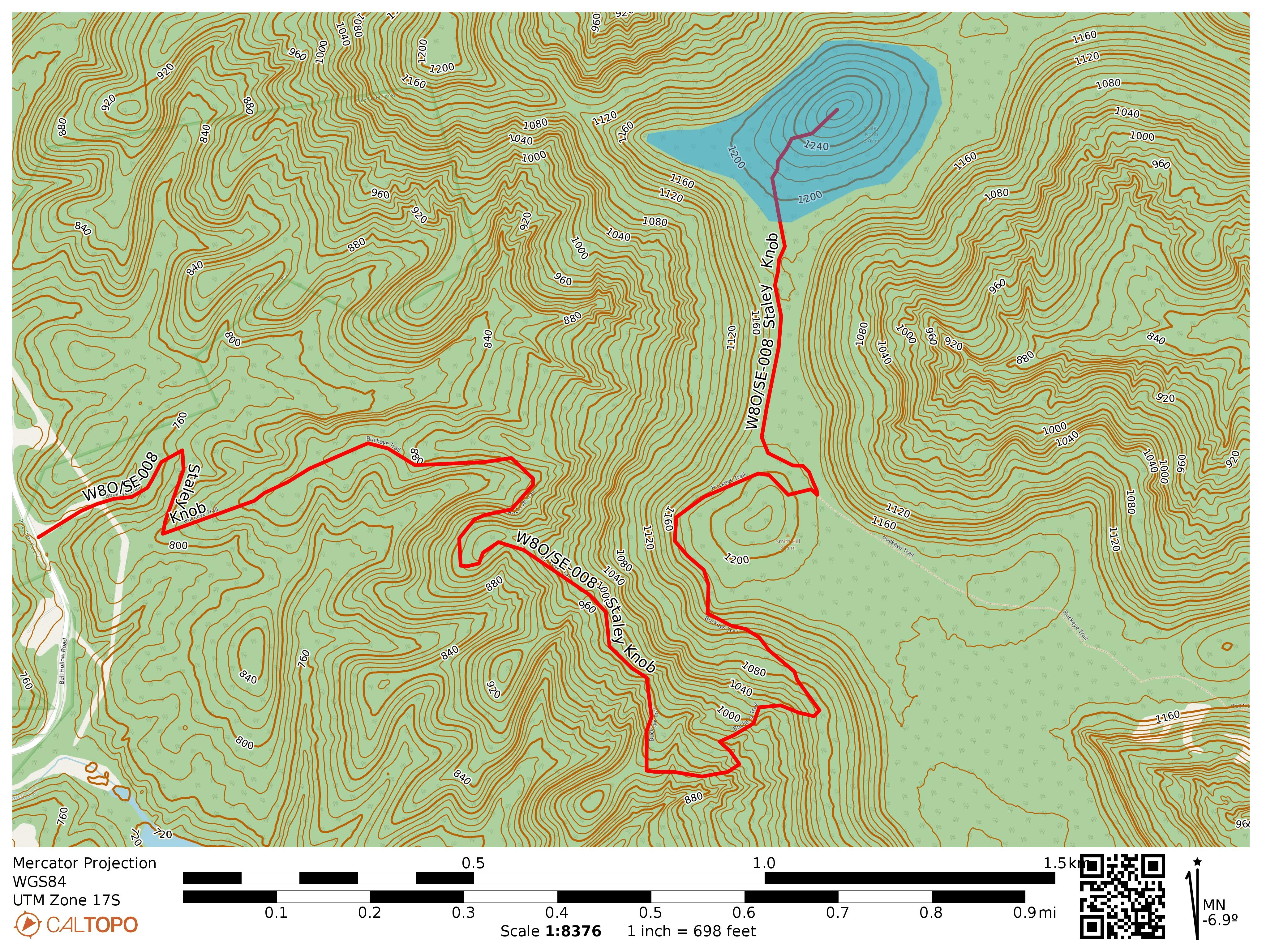
- Trailhead: 39.10312, -83.34455 : Red gate off of Bell Hollow Road
- Maps: [AA3TZ SOTA] [Buckeye Trail | Sinking Spring section]
- Route: 5.0 mi RT hike, ~2 mi on Buckeye Trail and 0.5 mi off-trail along ATV/deer path each way
- POTA: None, Cave Lake Camp is private property


