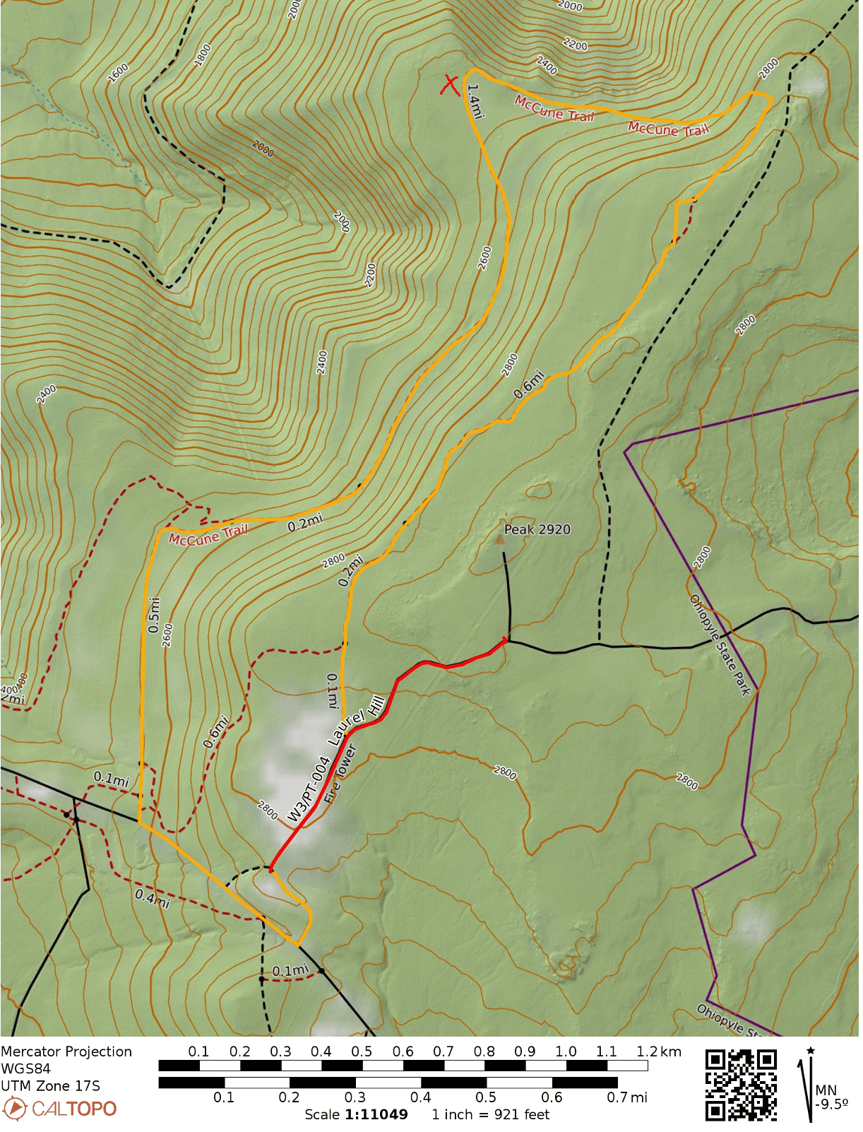
Took a daytrip to Ohiopyle State Park to check out this SOTA peak, which is in the more secluded eastern half of the park. Sugarloaf Knob (2667 feet), is the highest named peak in Ohiopyle, but the ridge extends to the east towards a less distinct high point (2930 feet) where the activation zone lies. I parked at the end of Fire Tower Road, which has a small parking area good for about 5 cars, and then walked along the gravel road about a 0.5 miles until I reached the final summit approach.
Fire Tower Road continues northeast here, while there is an overgrown road with many fallen trees in the path leading to the actual peak. The grass has gotten rather tall, and since this junction is in the activation zone (at approximately 2880 feet), I decided to avoid the potential tick encounters and operated from this junction. There were plenty of trees to get an antenna up, and I spent a good time getting chasing some S2S contacts once I had filled my log on 40m and 20m.
After packing up, I decided to finish the hike by taking the connector that leads to the McCune Trail, a quarter mile from the trailhead. The McCune Trail is well-marked with red blazes, and loops around the eastern Sugarloaf ridge and has some interesting looking boulders scattered along the way. There is a scenic bench with views of the Great Allegheny Passage trail and Youghiogheny River that would be spectacular during fall and winter. This added about 3.7 miles to the total trip. I did awkwardly walk along Sugarloaf Road at the end to cut off some distance, but very few cars appear to use the road.
Summary of the day. The red path is the short walk along the gravel road to the activation zone. The yellow path is the route around the McCune Trail. The approximate location of the scenic bench is marked with a red X.
Trailhead: 39.82497, -79.44109 : A small gravel road leads to this parking area off of Sugarloaf Road
Route: 1.0 mi round trip, following the gravel Fire Tower Road (a car with clearance could probably drive onward to the AZ); McCune Trail adds approximately 4 miles, and is worth it! A large part of the trail passes through the AZ.
This was a quick one on a drive from Cincinnati to Pittsburgh. As reported by others, Flint Ridge Memorial State Park is a short detour north of I-70, taking less than 10 minutes to get to the park from the highway. The picnic area by the parking lot is within the activation zone, so this feels a bit more like a POTA activation since there is no hike to a summit. The actual peak is about a mile west of the park, evidently in somebody’s backyard. The titular Flint Ridge is an 8-mile-long vein of flint that was quarried by the Hopewell people in ancient times.
The activation zone is wide and encompasses the entrance of Flint Ridge State Park (right-side of image). The triangle marks the approximate location of the high point, and the 80 foot region beneath the activation zone is shaded. I operated at a spot in the park marked by a circle.
The highlight of this activation was working sideband summit-to-summit contacts with Martha W0ERI and Gary W0MNA on W0D/BB-089 in South Dakota. They’ve chased me on many of my activations, so it was neat to get them in my chaser log as well!
There is a museum about the ancient flint quarry at this site, but it was closed since I was there on a Monday. I just set up at a park bench next to the lake and operated. Seems like there would be more to check out on a longer visit in the future. This also feels like it has the potential to become a state park (i.e. a POTA park), but is not yet one. It’s also close to the Newark Earthworks, which I will definitely visit on my next pass through!
Trailhead/Parking: 39.988759, -82.261710 : Flint Ridge State Park lot; 15300 Flint Ridge Road, Glenford, OH, USA
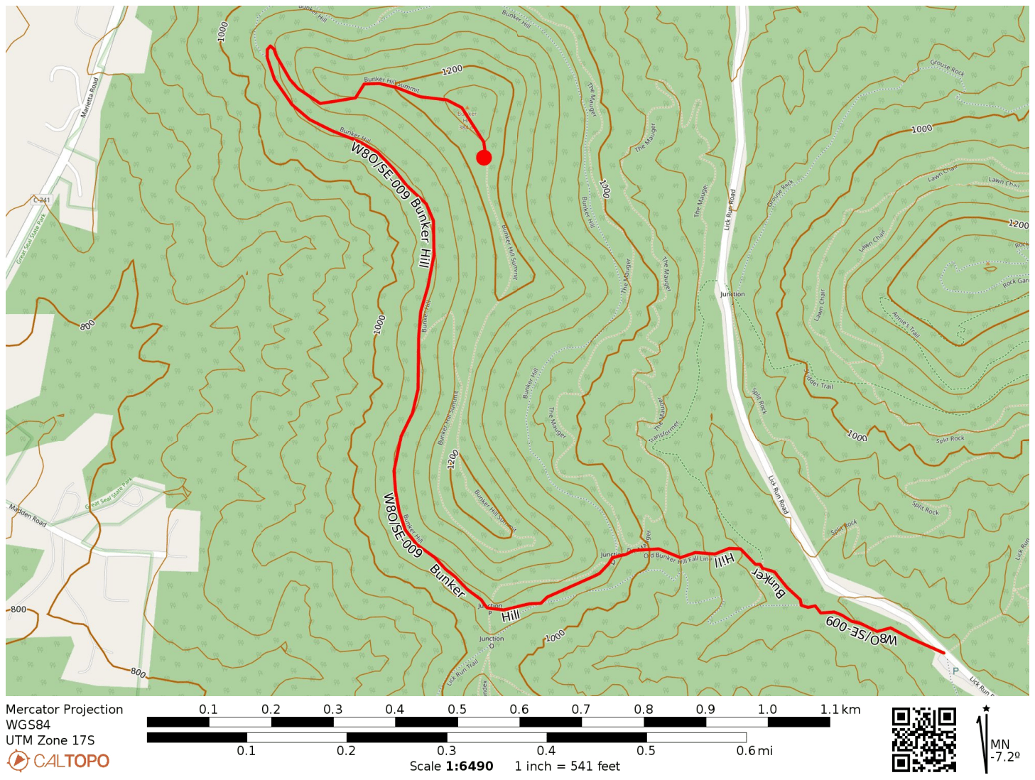
On a drive to Cincinnati for a family visit in July, I picked out a detour around Chillicothe to take on a couple SOTA summits: W8O/SE-009 Bunker Hill and W8O/SE-005 Rocky Knob. I had just worked Chris N8PEM on his activation of Bunker Hill a few days before this trip, and his reports for the area were invaluable for planning.
Bunker Hill is within the Great Seal (of Ohio) State Park and Rocky Knob is just outside its bounds. I thought this was an odd name for a park, but it turns out that Chillicothe is the city depicted in the Great Seal of Ohio, as it was the state’s first capital city.
I parked at the mountain biking trailhead off of Lick Run Road. The Mt. Ives trail starts from this point, which fans out into a network of trails throughout the park. First up was Bunker Hill.
W8O/SE-009 Bunker Hill
I followed the Mt. Ives Trail, then the Shawnee Ridge Trail, to the Bunker Hill Trail which snakes its way up the hill. The trails and junctions are well-marked. I did pass by a few mountain bikers on the way up. All told, it was 1.5 miles one way with nearly 500 feet of elevation gain. The majority of the hike was flat as the Bunker Hill trail mostly follows one contour around the hill until the last push to the top.
The activation zone at the top is large, so I hiked a bit further past the true summit where there was more room to set up. I used my trusty throw line to get the end fed up. Since this was a POTA site, I quickly got the required contacts, putting 17 in the log in about 25 minutes. Since the next hike was a bushwhack, I wanted to give myself plenty of time, so I decided that was good enough.
Trailhead: 39.36710, -82.93829 : Mountain Bike Trailhead on Lick Run Rd
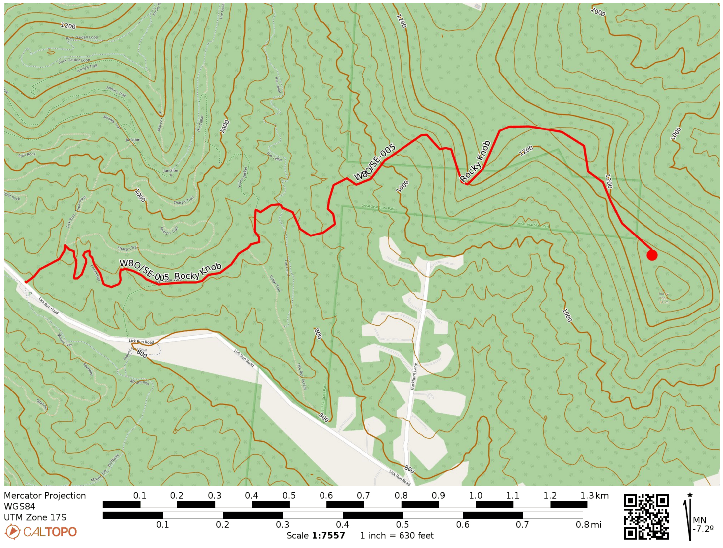
Back at the car, it was time for hike number two. Rocky Knob, as of this writing (Feb 2025 – this report has been on the back burner for a while 😬) has only been activated 9 times to Bunker Hill’s 41. This is because Rocky Knob is a bushwhack. While a tract of Great Seal State Park connects nearly the entire way to the hilltop, the least strenuous way does pass momentarily across a well-trimmed lawn (private property) that is not within the park.
I started on the Lick Run Trail and after a tenth of a mile, followed a Connector trail to Lower Cellar Trail, working my way to the east end of the park. Once I had crossed the Cellar Trail proper, it was time to start the bushwhack.
Lick Run TrailAround here is where I went off-trail.
I tried to follow this dried creek up the hill. It was somewhat rough going and the ground was softer. I kept consulting my GPS to try to stay in the park boundaries, which includes a narrow (tenth of a mile wide) panhandle to the east. The clearing just north of the park is an open, flat field that seems to be part of somebody’s property, so I did not linger.
Following the ridge got me back into the park for the final approach to Rocky Knob. There is a small wooded area surrounding some rocky protrusions at the top. There were signs of a recent campfire, with a small rock pit and firewood around. There were many trees to choose from to get a wire up into and a handful of rocks to sit on.
Even though the edge of the park boundary might overlap with the activation zone, I decided to operate closer to the peak south of the park boundary to be safe. I did a bit of S2S chasing here, logging a few prolific SOTA and high-profile activators. George KX0R on Radial Mountain (W0C/PR-091), Al N1SMB on Lily Mountain (W0C/FR-050), and Ara N6ARA on Kratka Ridge (W6/CT-014). 14 QSOs when I wrapped up. It was an uneventful hike back, but I did find a tick in my pants when I made it to Cincinnati a couple hours later. Thankfully, it hadn’t bitten.
Trailhead: 39.36710, -82.93829 : Mountain Bike Trailhead on Lick Run Rd
I had some time to drive up to Mt Davis on July 3 to see Pennsylvania’s high point at 3213 feet. This is the most activated SOTA peak in the W3 area, with my activation making it 125 to date. The summit is surrounded by the Mt Davis State Conservation Area (US-0625) which is also part of the Forbes State Forest (US-5468), making this a double-POTA activation.
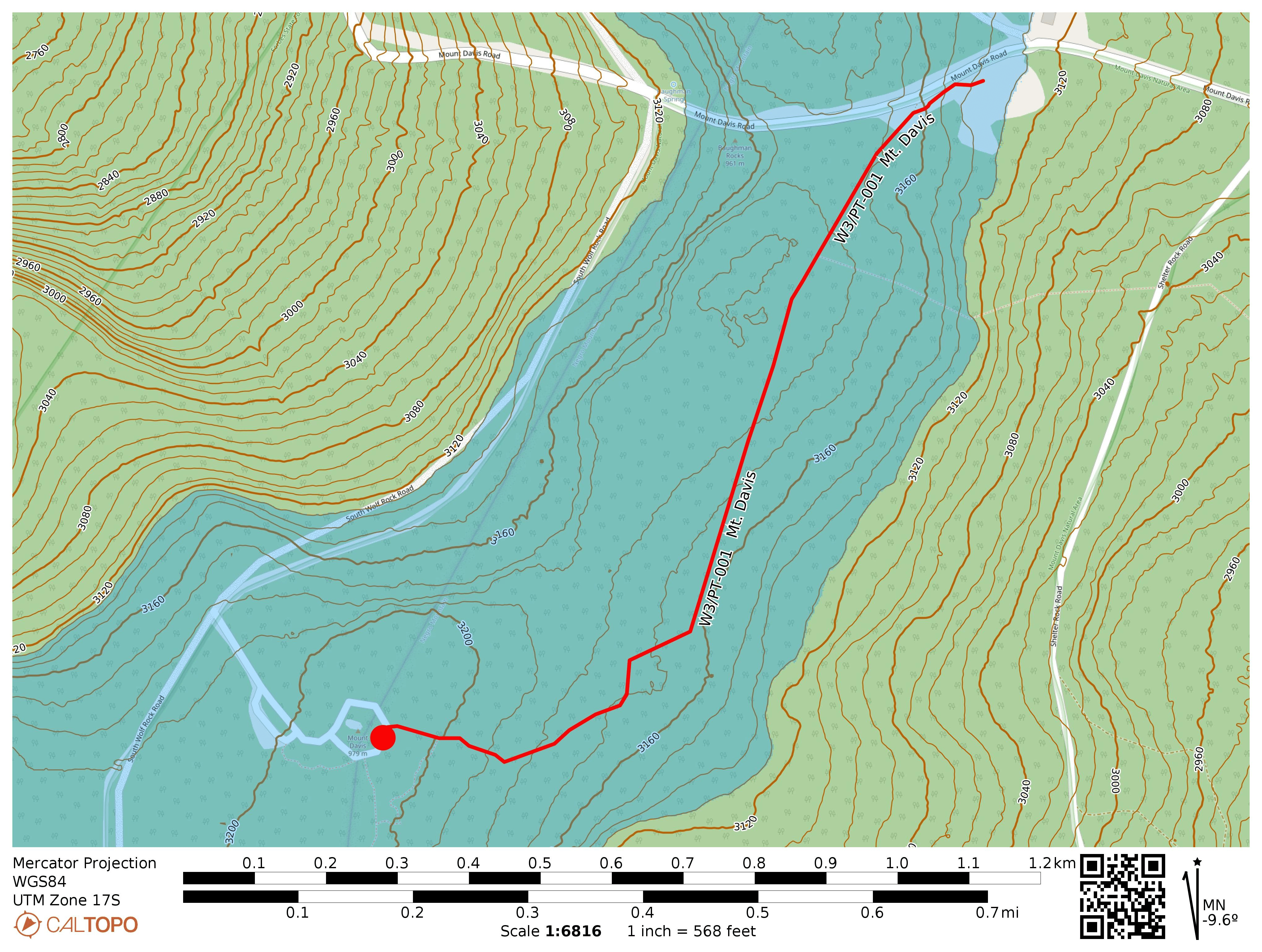
While it’s possible to drive to within 300 feet of the peak, I opted to park at the High Point Picnic Area for a mile-long hike to the observation tower along the High Point Trail. This mostly-flat trail is part of a greater ~5 mile loop that tours this chunk of Forbes State Forest. I might try that loop next time.
I took the stairs up the observation tower and had a look around. Despite being the high point, Mt Davis is not particularly prominent, so the observation platform lets you see other ridges around the area. Once I was satisfied, set up near the paved loop by a stone pillar that was once a signpost. A disused trail spur entered the forest for about 40 feet or so, which was a perfect place to string up the end-fed. An easy way to earn 10 SOTA points!
Trailhead: 39.79417, -79.16653 : Northwest end of the Mt Davis Picnic Area.
Route: 2.0 mi round trip, following the High Point Trail
POTA: Mt Davis State Conservation Area (US-0625); Forbes State Forest (US-5468)
Update18 July 2025: This is a broad activation zone, as is typical for PA. The westernmost couple of benches in the Mt Davis Picnic Area are within the AZ! You can do this one POTA-style. I added this activation after completing Boardman Ridge, using the easy location as an opportunity to try my FT891 in the field; QRO for the first time!
The QSOs came in fast, but the rain came faster. I had to pause in the middle to wait for a break in the rain, then racked up a few more before the rain picked up again and forced me to pack up. 32 QSOs total, pieced together from two short runs punctuated by precipitation.
Update14 Feb 2026: The Mt Davis picnic area makes for a great spot to do a winter activation. Deep snow engulfing the tables, but little wind. A couple of snowshoers visiting from Maryland passed by to ask about my setup. This time, I was using the Sotabeams 20-30-40 linked dipole and FT891 for QRO fun, logging 120 QSOs! Fun DX included Finland OH1MM and Iceland TF3DC, both on 20m!