This was an enjoyable way to slowly say farewell to the East Bay while I was finishing up with graduate school. Such an amazing variety in landscapes, all within a 30 min drive! It will be hard to say goodbye.
In July, I had the fortune to visit Hawaii, starting at Maui and moving on to Honolulu, Oahu for the IEEE Engineering in Medicine and Biology Conference, where I was presenting a paper. While on Maui, I visited and activated the great shield volcano Haleakala, which comprises over three-quarters of the entire island. It’s an enjoyable, winding ride up to the visitor center and eventually the Red Hill summit at 10,023 feet, upon which there is a small observation room. From here are beautiful views of the Hawaiian islands and the massive, sloping sides of the great volcano. The last eruption of the volcano was approximately during the 17th century, when a small eruption created the lava fields surrounding the La Perouse Bay on the southwest part of the island, which we hiked along later in the week to visit the Hanomanioa Light signal along the coast.
Looking down the peak
Observation deck
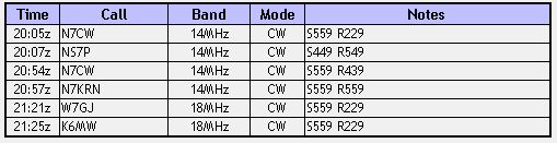
Reports were coming back around S2-S3, which makes sense for transmitting QRP far from the West Coast, and I was there for about 90 minutes for the entire activation, hanging out near the observation building on Red Hill. I had 4 QSOs on 20m, then moved to 17m for the last two contacts.
Thanks to all the chasers, as always!
As a bonus, here are some pictures of the lava fields around the La Perouse Bay:
Another ham radio year, another trip to Vollmer Peak, my first SOTA hill. I activated this peak every year since my first activation on March 14, 2015, which was my re-entry into the amateur radio hobby. Since I’ll be leaving Berkeley this autumn, Vollmer will no longer be my “home” peak, so my June 30, 2018 activation will be my last visit for a while. This was a wonderful place to visit after work to contemplate, reflect, and occasionally play with radios.
2015
2016
2017
2018
Thanks to all the chasers: AA1FD, N6DAL, KK6VQK, W6CTQ, WU1Q, KM6MRU, K6WIS, KB6KHP.
Some fun facts about Mount Eddy (elevation 9025 feet), near the old logging town of Weed, CA:
It’s the high point of Trinity County, the Trinity Mountains, and the parts of the United States west of Interstate 5
It’s named for Olive Paddock Eddy, who was the first woman to summit Mount Shasta
It has beautiful views of Mount Shasta
The summit is often overlooked in favor of the majestic Mount Shasta, which is nearby and 5000 feet taller. The hike is relatively accessible, about 8 miles out and back along part of the Pacific Crest Trail with 2500 feet of elevation gain.
We started at the Deadfall Meadows trailhead and followed the path to the spectacular Deadfall Lakes. From there, the climb became more strenuous, with numerous switchbacks until we finally reached the summit.
Deadfall lakes
Onwards towards Eddy
The switchbacks…
Shasta from the summit – some snow on the north face
I had an easy time on 20m CW, and before long it was time to head back. Thanks to all the chasers: K9PM, W7RV, K6HPX, NG6R, N6PKT, NQ7R, K5DEZ
On April 9, 2018, I went to Las Trampas Regional Wilderness for a quick and simple activation, using just an HT and whip antenna. I started at Bollinger Canyon Staging Trail, and climbed the ~1000 feet to the summit on a paved trail for most of the way.
It’s the low-key sort of activation that’s really only possible in the Bay Area with its large and supportive ham community, and I’m going to miss that when I leave.
Thanks to the chasers: K6FRC, KM6MRU, N6YJZ, K6WIS.
I had the good fortune to accompany Jeff AA6XA on a hike that he had been eying for some time in the Cedar Roughs Wilderness near Lake Berryessa. The high point of this area is not often visited, since it requires an off-trail approach through somewhat dense vegetation. As a consequence, this 2368-foot peak had not yet been activated for SOTA.
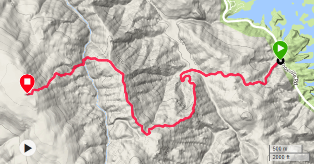
We parked in the Smittle Creek Day Use Area, and headed down the road a few hundred feet to the trailhead. We hopped over the fence and started down the trail, which was more of a dirt road that had seen some recent traffic. We went along the trail, taking care to choose the correct turn at a number of forks, guided by GPS tracks left by some users on Peakbagger. Lake Berryessa had some white capping today, and the breeze was starting to feel nice and strong as we climbed. After a gradual climb from 500 to 1800 feet over the first three miles, the trail declined steeply towards a pair of rock pinnacles, each about forty feet tall. 3.5 miles down, and only one to go. Of course, that last one was off-trail.
Parking lot
Gate
Lake Berryessa
Approaching the pinnacles
I’ve been on a lot of hikes, but I haven’t had much off-trail experience, so when Jeff warned me that there would be some “bushwhacking,” I didn’t think much of it. Here we were, we just had to drop a couple hundred feet to the so-called Trout Creek and climb the rest of the way up. The pinnacles are the point where most others decide to move off trail, so we followed suit. The best descent was a sharp chute between the pinnacles. “The earth is loose so you can get a reasonably good foothold,” Jeff called up, already twenty feet below me. I nervously procrastinated for a few moments by incrementally and repeatedly readjusting my pack and antenna mast. The ground indeed made nice footholds under my weight and supported a fast descent.
Before long, we had made it to the creek. We crossed and started to find our way through to the top of the peak. As others have reported on Peakbagger trip reports, the bushwhack is relatively “mild.” A number of times, we came across some extremely dense cover, backtracked a few hundred feet, and found a more open way up. We also recrossed the creek a couple times to find the past of least resistance before making our way to the top in earnest. There were some enjoyable moments where we reached a small open patch, but the majority of the climb was a careful slog through trees and felled branches. After an hour of climbing, including a couple stops, reversals, crawls, and scratches, we had made it to the summit. I guess it wasn’t as bad as it could have been. Although the few times we stopped in front of a wall of branches made me break out in a cold sweat, there was always a less intimidating way up.
Looking up at the pinnacles
Dropping down the chute between the pinnacles
Trout Creek
View of the slope to the summit
Sometimes the woods would open up
Other times, the brush got dense
The views were obscured by trees the entire way
The cairn at the summit
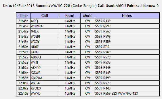
We signed the summit register, hidden inside a cairn, (only about 10 or so had signed it in the last couple of years) and set up. The soil was easy to stake so guying my fiberglass mast was an ease. There was also good cell service at the top for spotting. After Jeff cleaned up on 30m, I got my contacts on 20m. We both stuck to CW and had an easy time of things. Near the end, WW7D caught me for a S2S on 30m (he was on W7W/KG-123 Black Devil, near Seattle).
We ate, packed up, and then headed back. We beat the sunset to the parking lot by 45 minutes or so, which was useful considering that the lot closed at sunset. By then the entrance had already been gated off, and a ranger was driving around checking out some of the other parked cars. Exhausted from the ~9 miles we hiked, I was happy to leave. Cedar Roughs now has two activations on the books!
For the first activation of the new year (on January 12), I went with a group of friends to an unnamed peak near South Lake Tahoe. We were in the area to do snowshoeing over the weekend, but the weather was balmy (over 50 Fahrenheit) and there was no snow between the trailhead, at an elevation around 6300 feet, to the peak at 7008 feet. This peak is worth 6 SOTA points and qualifies for the winter bonus.
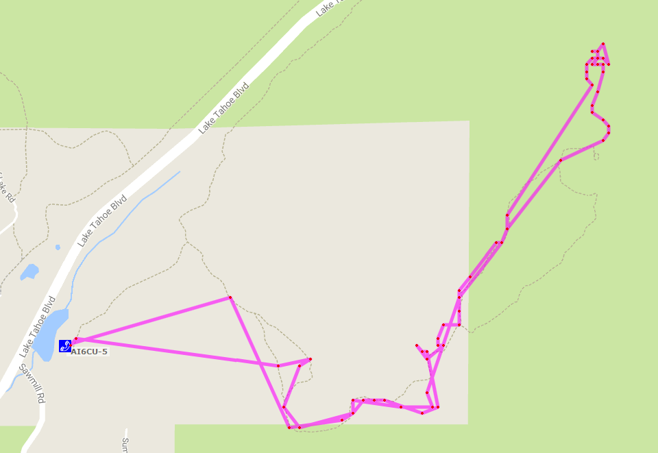
The trailhead is in Sawmill Pond, a “training lake” which is a stocked fishing pond managed by the USDA Forest Service that only allows children 14 years and under to fish. We took a straightforward ATV trail that went most of the way up and ended in a loop. At the loop, and had to go a bit off trail to the northwest to finish the hike. The summit is marked by a torn US flag on a steel pole in the rock.
Sawmill Pond
Approaching the summit
The flag visible at the rocks on the summit
View of Lake Tahoe from the summit
A nearby airtstrip
The soil in the ground was soft and easy to put my tent stakes into for pole mounting. The contacts came easily on 20m CW, including JH1MXV in Japan!
Hamming in the sun
On top
Teaching my friends about ham radio. Well, 4/5 (including the photographer) on this hike were hams, but I’m the only active one
The next day, we were snowshoeing around the Mt. Rose area and I managed to hear KK6YYD on 2m FM, who just so happened to be activating this very peak, adding this to my SOTA completes list in just 24 hours! I think this is a popular peak, as it’s quite easy to hike up in the winter and get the bonus points, and an accessible hike in the Lake Tahoe area.
The APRS track. It’s a bit undersampled, but you can more clearly see the route we took off-trail to get to the summit.
Thanks to all the chasers: JH1MXV, W0MNA, W0ERI, N4EX, W5GAI, and W7GA.
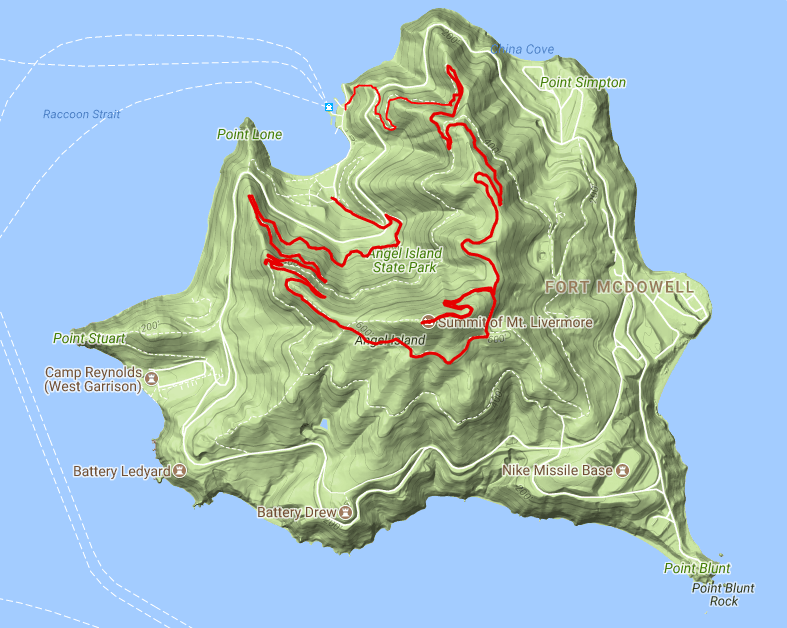
On December 16, we (KK6STE and I) drove down to Tiburon to take the ferry to Angel Island for a SOTA activation on Mount Caroline Livermore (W6-CC-076) tackling the nearby Tiburon Peninsula high point afterwards (W6/NC-435). We found $5/day parking near Tiburon’s main street across from a Woodlands Market, about a five minute walk from the ferry station. Paying for parking is a bit old-school: you have to stuff a fiver into an envelope and drop it into a box, so be prepared with cash! The ferry costs $15 per adult (cash only, again!!) and is the only way onto the island (unless you decide to kayak). It’s a short ride, about 15 minutes to cross the short Raccoon Straight. We took the 10:00 am ferry and decided to be sure to make it back for the 1:20 pm return trip (the last trip leaves the island at 3:20 in December).
We took the North Ridge Trail to the summit and meandered down the Sunset Trail for our return path, which seems to be the most commonly suggested route. There were a good number of hikers on the path since it was a beautiful, clear day. The trail resembled more of a staircase than a hike for the first bit. One half of a couple in front of us groaned as he turned to face us, complaining “she wants to run” as his partner was jogging up the staircase. I recommended that he go catch up while we went with the rational decision of walking up the staircase. After 100 steps or so, we reached the perimeter road, across which the actual trail starts a gentle ascent to the summit at 788 feet. The round trip was roughly 4.5 miles and there were spectacular views of the bay all along.
At the very top are a couple of picnic benches. If you continue past the summit down the trail, you will reach a dead-end with some more benches. I decided to keep things low-key today given the number of other hikers, so I kept with the 5W HT with a simple whip antenna and had a large number of contacts from all around the bay. It was interesting to see the bay from the center looking out, as opposed to looking in at it from its perimeter. From this perspective, you can see all the bridges that cross the bay circling around you, as well as the mountains that surround the area (including Mt. Tam, Mt. Diablo, Mt. Saint Helena, et al.).
Ayala Cove of Angel Island.
A look back at Tiburon from the trail. The Tiburon Peninsula high point is visible, and was the second stop on our day trip.
Perhaps the most famous bridge in the world?
Richmond-San Rafael Bridge (aka “Roller Coaster Bridge)
Bay Bridge (check out the reflections from the slanted roads of The City!)
Alcatraz, The City, and reflections on a clear day.
Here, I got to make contact with a number of hams that are active in Bay Area SOTA, including Rex KE6MT, Alex KK6ZLY, and El K6EL. All told, I was able to get nine contacts in twenty-five minutes on 2m simplex, thanks to Rex’s spot: AA1FD, KE6MT, W5GCL, K6EL, KK6ZXH, KK6ZLY, KM6KGI, K6ZTF, and WU1Q. Having saltwater 360 degrees around me seemed to help a lot!
We got back down to the visitor center with time to spare, so we took a look and learned a bit more about the history of Angel Island. There are buildings around from when it served as a port of entry for immigrants to the western US, and people were kept in quarantine for as long as six weeks to make sure they weren’t harboring disease. Once modern medicine introduced better screening techniques, the island was used primarily for military purposes, including a Nike missile defense site. By the 1960s, the entire island was a state park led by efforts by the Marin County conservationist Caroline Livermore (the island mount’s namesake).
Our path took us around to see a good chunk of the island.
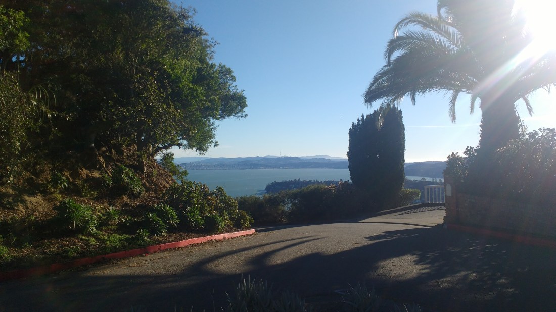
After getting back to Tiburon, we took the 6-minute drive up to the highest point on Tiburon, another SOTA destination. The actual peak is in somebody’s yard in a quiet neighborhood, but there’s a small bench within the activation zone that other hams have operated on in past activations. I sat on this bench and enjoyed the view of SF from here and decided to keep my activation low-key (HT only, no big wire antennas or multi-element monstrosities) out of respect to the residents. At times, a number of people walked by, but they didn’t seem bothered by me operating at the bench at all. In any case, my self-imposed limitations led to a frustrating 50 minutes during which I only made 3 QSOs: AA1FD in the South Bay, AG6QR crossing the Richmond-San Rafael Bridge, and KD6GGJ in El Cerrito. I tried in vain with KK6VQK for quite a while to make a simplex contact after he came back to my call on the N6NFI repeater, despite his patient attempts to catch me and AA1FD’s help as a relay. After trying fifteen more minutes for the last contact, we decided to leave. Alas, I won’t get that single SOTA point the summit offered, but it was still nice to get a few contacts from up there.
View from the neighborhood bench.
After the day’s activations, I have earned 50 SOTA points as an activator. As always, thanks to all the chasers!
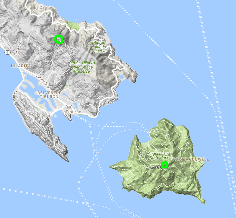
This map shows the scope of the day, with both peaks marked by a green circle. As you can see, it’s pretty easy to combine the two into one trip.
On December 3, I drove down to San Jose to check out Mount Isabel, which lies on formerly private ranch land recently acquired by Santa Clara County. I was hoping to be first up this peak for a SOTA activation, but AA6XA beat me to the punch. His notes helped me find the route up the peak, but I still managed to get a bit lost on the hike.
I parked in Joseph D. Grant State Park at the Twin Gates parking lot, on SR-130 about a mile west of the CalFire Smith Creek Fire Station and started on the Bonhoff Trail. In hindsight, it would have been best to park in the pullover just across the bridge from the fire station, since this short segment within the state park was a little hillier than expected and added about 2.4 miles to the round trip.
Once I made it to the fire station, I crossed Smith Creek and followed it east along the fence once I made it to the fire station, but I believe I might have missed when the trail to Mount Isabel got started. About a mile along the fence, I decided to just climb up the hill to the north and get a better view of what was coming. I was a bit surprised to see a large wild pig about 300 feet up the hill, who thankfully decided to cede the high ground and run away from me. Once at the top, I was able to catch the main trail ahead of me. I followed it and it eventually took me back down to the creek (d’oh!) and then to the climb up Mount Isabel. Along the way up, I saw another wild pig, a number of deer, and many groups of California quails.
Part of the way up, the trail starts to follow a barbed wire fence with the summit in view down the line. At some point, the barbed wire is stretched apart to make it easy to pass to the other side to make the final approach along the ridge to the peak.
Where I parked.
The trail is pretty easy to follow once you make it to the crossing at the creek.
Following the trail along the peak.
The break in the barbed wire fence to cross to reach the final summit approach.
The summit.
A view from the summit.
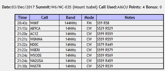
The summit had plenty of trees and bushes to hang wires up on, and there are some good views of the University of California’s Lick Observatory on Mt. Hamilton to the north. I chatted a bit with W6KF on 2m on my FT60 with a whip antenna (he was about 50 miles away) and then tossed a wire up into a dead tree for 20m CW on the KX2. AB9CA caught me early on and spotted me, so I soon had plenty of contacts.
On the way back, I followed the trail all the way to SR-130, where it met a bit down the road from the fire station, so I had to amble down a steep hillside to make it back. This would be another good starting point for the trail. All my detours ate up so much time that I didn’t have quite enough daylight to make it out to the nearby Copernicus Peak at the Lick Observatory (another SOTA peak and the tallest point in Santa Clara county), but I will return!
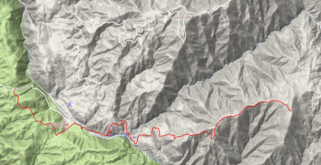
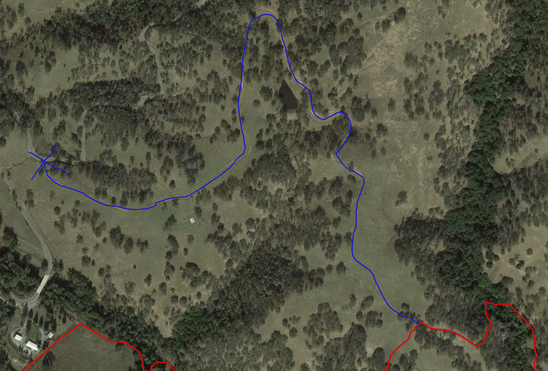
The one-way path took 5.14 miles and nearly 2500 feet of elevation to get to the 4230 foot peak. I’ve attached a GPS map of my course, along with a dotted blue line to denote the recommended path that sticks to the creek until the path crosses it. I’ve also used a blue X to mark the point where the trail meets SR-130 and would be a good place to park and follow a trail the entire way rather than following the creek.
My GPS track on the way up. You can see where I left the creek to try to find the trail, and how I followed the trail back to the creek. The dotted blue line is a suggested alternate route. The blue X shows where I finished the hike, having followed the path all the way back to the road rather than follow the creek back to my starting point.On my way back, I followed the trail past the creek along this path that is clearly visible from a satellite image. The blue line traces over this path and would be a reasonable way to tackle this summit.
Thanks to all the chasers for making this a successful outing (and to AA6XA for blazing the SOTA trail)!
Over Thanksgiving weekend (November 26), I checked out this easy drive-on peak near Laguna Beach that’s well-known to the people of Orange County. There were a lot of folks there to watch the sunset, and it was a truly spectacular sight with the low-rolling fog and clouds. A few people were flying drones around to film the scenery.
I used a small bush near the top to hold up my antenna and got to work. The bands were packed due to the CQWW CW contest, so I just picked off a few contest stations on 20m while watching the sun set.
Thanks to all the (contest) chasers: N7DR, JH4UYB, BY3M, and KH7B.












 Tom Zajdel