W6/NC-410 San Pedro Mountain

Another sunny day in The Bay, another SOTA activation. This time we went out to Marin County for San Pedro Mountain (1099′ and 1 SOTA point), northeast of San Rafael. We drove out to the trailhead at the end of Knight Drive on the south central border of China Camp State Park as activators before us have done (K6JEL’s write up).
route1.png
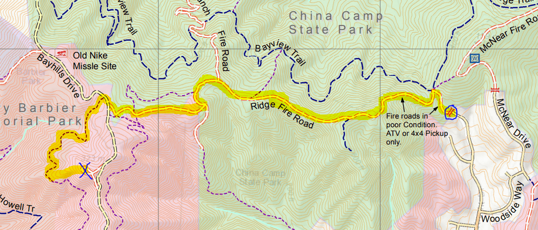
The start is marked with a blue circle and the summit is marked with a blue X. The route that we took to the summit is highlighted in yellow. Map courtesy of Larkspur, CA City Hall’s webpage.

We started at noon, so the July sun was a beating down hard on us. We followed the Ridge Fire Trail, which for the first half mile is an exposed climb from an elevation of 200 feet to 600 feet that would have been much easier earlier in the day. After that, the trail is more even with a few more gradual climbs and one dip. Near the end of the trail we came to Bay Hills Drive and Henry Barbier Memorial Park (which are both unsigned). We crossed the road to another trail that starts about 100 feet to the right. This trail just took us along a ridge around the mountain, though it was shaded by tree cover and a welcome respite. We ended up taking a use-trail up to the summit and returned via Bay Hills drive on the way back, covering about 4 miles overall. We recommend just turning left at Bay Hills Dr to get to the summit.

At the flat summit, trees block most of the nicest views, we got our sightseeing done on the way up the trail. I got a couple of quick 2m contacts with the handheld and a whip (KI6UOC and N6SPP), then moved to a low end-fed for 20m CW for the rest (W6TDX, VE7HI, K3TCU, K6HPX, N9KW, KT5X, W5YA). Thanks to all the chasers!

W6/NC-432 Chabot 2 Benchmark

Today we went to Chabot Regional park to pick up an easy 1-pointer in the East Bay: Chabot 2 Benchmark. We parked in the Fairmont Ridge Staging Area, where parking was free. It was late afternoon and above 80 degrees Fahrenheit (27 Celsius or so) but mercifully the hike was only about a mile each way, and half of it was shaded by a row of eucalyptus trees. Near the top is a fence that blocks off a historic Nike missile site. This gate is just within the activation zone, but I followed a use trail just left of the fence to get a bit closer to the summit, although it seems the proper way to do this would be to peel to the right of the eucalyptus trees on the east side of the antennas and missile site.

I brought a log-periodic with me for this all-VHF activation, but I probably didn’t need it since most of my contacts were located about five miles away in Hayward. At this time of the afternoon people driving home from the day’s activities, so a lot of folks caught me on the road.

Thanks to all the chasers: WU1Q, KG6OMB, N6ACK, AI6F, KK6WBY!

W6/CC-035 Mount Konocti

We were camping at Clear Lake State park for Memorial Day weekend to check out the lake and the surrounding region. Mount Konocti is visible from nearly any point in the region around the lake and has special significance for the indigenous Pomo people. The trailhead is in the Mount Knocti County Park, which opened this peak to the public in 2011.

The hike up to Wright Peak was three miles each way and was exposed to the sun for most of the way. The first 600 yards of the trail is narrow and goes through some privately owned orchards. We were glad that we started at 8am since the trail is on the west side of the mountain and was therefore shaded most of the way up in the morning. We saw a rattlesnake slide into the grass just off the trail near the summit and there were many lizards darting across the trail so watch your step!

We were the first ones on Wright Peak that morning and I had an easy time with the activation on 2m thanks to the active (and very helpful) ham community in Lake County. I even managed to get a S2S with KK6YYD on Wallace Peak near Lake Tahoe. When it came time to set up the HF antenna, I got the fiberglass pole up and guyed before I realized that I forgot to bring coax with me this time! Whoops… one still learns even after doing 25+ of these trips…

Thanks to all the chasers for this all-VHF activation: KK6TDG, KK6YYD, KK6TNH, K6ZYU, and N1PPP!

W7W/LC-146 – Wind Mountain

On March 29, we were driving along the Columbia River Gorge to sight-see. After a wonderful hike to the top of Multnomah Falls and lunch in the town of Hood River, we crossed the river over to Washington state to climb Wind Mountain with the radio. We had a false start up a steep use-trail that quickly turned into an overgrown mess but we did eventually find the proper trail, which was about 2.5 miles round-trip with just about 1400 feet of climb.

Once we reached the top, Wind Mountain had decided to live up to its name with the summit exposing us to sharp winds coming through the gorge. I quickly connected with KE7IN on 2m who noted that he could really hear the wind. Then I threw up a wire and got to work on 20m. When I heard Gary W0MNA return my call, I breathed a sigh of relief since I knew that Martha W0ERI would be right behind him. Thanks to Gary’s spot, I was able to connect with W5BOS before I packed it in since we were not prepared to hang out in the heavy winds for too long (and rain started to roll in). Thanks to those four for another successful activation!

W7O/WV-088 – Mount Pisgah

For spring break this year, I am taking a road trip up along the west coast to visit old friends and see new places. Along the way, there’s been plenty of time for radio! We stayed in Eugene, OR today and went to the Pisgah Arboretum (looks like we missed the Mushroom Festival by a few months…) to climb Mount Psigah. We took Trail #1, which is a short 1.5 mile hike with just over 1000 feet of elevation gain. It was a foggy day with some intermittent showers on the peak, but I was able to get the four contacts in.

Thanks to all the chasers!

mtpisgah_qsos

Failed Activations are still fun! – W6/NS-062 – Red Lake Peak

My graduate lab took a group retreat to the South Lake Tahoe area and the festivities included snowshoeing. We didn’t have a destination in mind, so I suggested why not go up a nearby peak and bring the radio along? We ended up at Carson Pass where we had easy access to Red Lake Peak (10063 feet!), which has the distinction of being the subject of the first recorded ascent of a peak in the Sierras. The ever-present Lt. John C. Fremont was involved, and from the summit he first spotted Lake Tahoe.

Our expedition was ultimately not so successful. It was relatively easy snowshoeing up the first 2000 feet, after which four of us broke off from the main group to take a stab at the remaining 1000 feet. After about 500 more feet of climing, we reached a lower summit. Up here winds were over 40 mph, which made the final summit approach along an exposed ridge much less appealing. On top of that, the prospect of eventually putting up a fiberglass mast without it sailing away was daunting. We decided to huddle behind a boulder to escape the winds, eat a few Nilla wafers, and then mosey on back.

Lessons learned:

  • Snowshoes are amazing!
  • Wind is… a force of nature
  • John C. Fremont’s been everywhere, man

We’ll have to return to conquer this peak another time. 3/4 of the successful SOTA activations were done during the summertime, so a change in timing may make things easier.

W6/NC-030 – Mount St. Helena

Another weekend, another SOTA activation. This time I went up to Robert Louis Stevenson State Park to scale Mount St. Helena. It was a long and somehwat boring hike, with lots of meandering switchbacks spreading 2000 feet of elevation gain over 5 miles or so.

I got to try out my new 31 foot fiberglass antenna mast, which held my end fed up well. I laser-cut a piece of acrylic to use as a guy ring and it worked well, though I think I was guying the pole a bit too low to the ground to be super effective and there were some frightening wobbles accompanying the stiffer breezes. I could probably improve the setup by staking the center of the mast, but all in all this wasn’t too bad for the first field test!

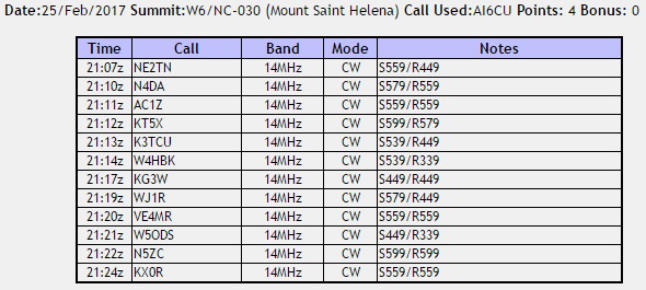
Lots of folks called in this time and the activation was very fast. Good thing, because it was rather cold and windy at the summit. Thanks to all the chasers!

sthelena_qsos

W6/NC-417 – Reactivating Abrott Benchmark and Hiking Kennedy Grove

On February 11, I returned to Kennedy Grove Park for my first hike for the East Bay Trails Challenge to get to know the regional parks a bit better. Of course, the radio came along so my group could make a SOTA excursion to Abrott Benchmark (here’s the first time I went with KJ6GLR’s company).

After one week of solid rain, this Saturday was a beautiful day with clear skies and a great time to return to this peak! Overflow from the reservoir was pouring down a spillway and the trail was quite muddy in places. The hills were a beautiful green this time around.

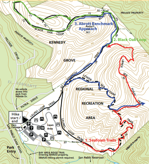
Our East Bay Trails Challenge started on the Laurel Loop Trail. We then went up the eastern Lower Sea Foam Trail to the Upper Sea Foam Trail to the Black Oak Loop Trail. We then came back down on the Kennedy Creek Trail to finish the loop.

kennedy_grove_hike.png

In order to get to Abrott Benchmark, we had to do a little bit of backtracking. This time we took the north leg of the Lower Sea Foam Trail and turned onto Upper Sea Foam Trail, but once we reached the high point on Upper Sea Foam Trail, we broke towards a fire trail on the east edge of the park that heads toward the peak. There’s a green swing near the entrance to the fire trail. You have to cross a fence to get to the trail, walking along a bit of grass in between. Take the fire trail to your left and you’ll make your way to the meandering fire trail that eventually takes you to the benchmark.

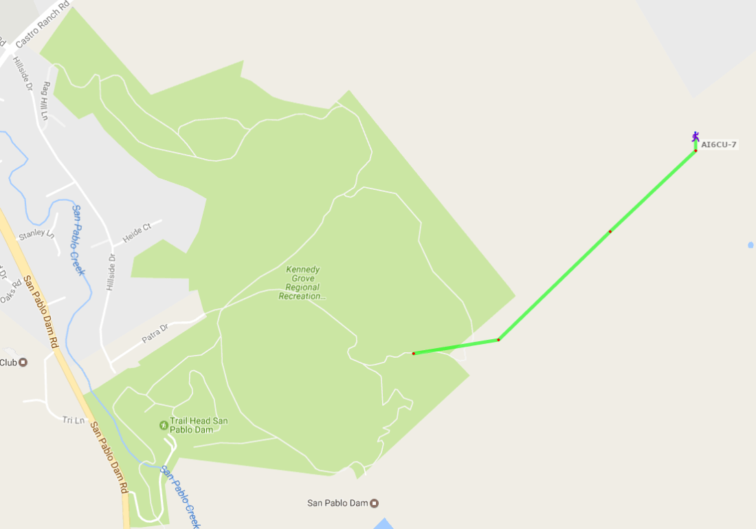
I also experimented with APRS location reporting. Nearly all the packets that I sent while on the Black Oak Loop were lost to the ether, but I managed to get a halfway decent track towards the peak. I was able to spot myself with the APRS2SOTA service, so everything was done on RF this trip.

abrott_aprs.PNG

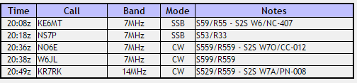
The contacts went by quickly, and I got a number of summit-to-summits this time. Of particular note was KE6MT who was just across the bay on Richardson East Benchmark, which I had activated a few months ago. It must have been a wonderful view that day! Thanks to all the chasers!

abrott_qsos


Re-activating Vollmer Peak (again!)

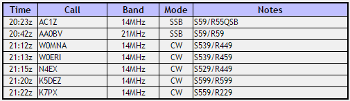
Another year, another trip to Vollmer Peak. Today (Jan 29) I took the KX2 with an MFJ-1899T whip to try a pedestrian mobile-style activation. Since it was a Sunday afternoon, the steam trains were running and made a nice background noise for the hike. My sideband signals seemed to make it out, reaching AC1Z in NH and AA0BV on Mount Caroline Livermore on Angel Island. For the rest, I had to crack out the CW paddle. W0MNA and W0ERI were quick to respond, as always. After a few more contacts, it was time to call it a day.

Thanks to all the chasers!

vollmer3_results

W6/CC-045 Mount Diablo (1173m) and W6/CC-051 North Peak (1084m)

I was very lucky to receive a KX2 recently as a gift from KK6MRI. I took the radio out on January 14 to two peaks for its maiden voyage: Mount Diablo and North Peak, and it was a joy to use. After this pair of activations, I made it to the milestone of 25 activator points. Slow and steady progress…

When we arrived at the summit parking lot for Diablo, it was still a bit early (just after 9 am) and we were not prepared for the cold, windy weather! We huddled in a small patch of woods on the summit trail near the parking lot to set up and stay out of the wind. I slacked a bit on finding a good spot for the antenna, so there were some difficulties getting out, but I did manage the four required QSOs.

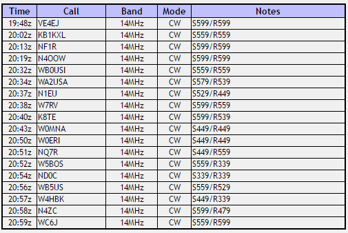
The hike to Black Point was about 5 miles round trip from the Mt. Diablo summit lot, and the last little bit to the summit of North Peak was very steep. The surrounding area was beautifully green due to the large amount of rainfall this winter. It had warmed up substantially by the time we got to the summit, so we stuck around for an hour, racking up 18 QSOs, which is a new high for me. I learned that my pileup-managing skills on CW (and my CW copy in general) could use work, and the increased activity from the North American QSO Party did not help, but fortunately the chasers were patient.

Thanks to all the chasers! Special shout-out to WBØUSI, WØMNA, and WØERI for catching me on both peaks this time. Looking forward to more activations this year!

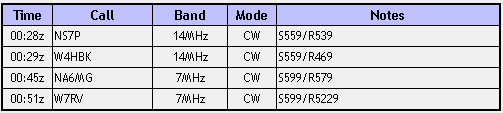
Mount Diablo:diablo_results

North Peak:northpeak_results